Charlotte Harbor (southwest Florida bay)

Coordinates: 26°46′33″N 82°08′31″W / 26.77583°N 82.14194°W
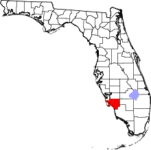
Charlotte Harbor (southwest Florida bay), the second largest bay in Florida[1] is located on the Gulf of Mexico coast of west Florida, mostly (2/3) in Charlotte County, Florida with the remaining 1/3 in Lee County. The area is also identified as the Charlotte Harbor Estuary. The harbor's mouth is located behind Gasparilla Island, one of the many coastal barrier islands on the southwest coast of Florida, with access from the Gulf of Mexico through the Boca Grande Pass between Gasparilla Island on the north and Lacosta Island on the south. Charlotte Harbor covers about 270 sq mi (700 km2)[2]
The harbor is fed with fresh water from the Myakka River on its northwest corner and the Peace River on its northeastern corner. Charlotte Harbor is bordered by the communities of Boca Grande, Charlotte Beach, Port Charlotte, Charlotte Harbor, Punta Gorda, Pirate Harbor and Bokeelia. Charlotte Harbor connects to San Carlos Bay to the south by way of the Pine Island Sound and the Matlacha Pass.
History

Prior to the first Europeans, Charlotte Harbor was the home for settlements of Native Americans of the Timucuans Calusa group who occupied southwest Florida.[3] At the time of early Spanish explorations, an Indian village, Ucita, might have been located near present day Tippecanoe Bay in the northern part of Charlotte Harbor, west of Port Charlotte - but this is currently debated by historians (read a definitive work on this subject within: Duncan, David Ewing. Hernando de Soto, A Savage Quest for the Americas. Crown Publishers, Inc. (New York, NY 1995), ref. p. 255 & p. 486-492. Link to excerpts from Duncan's book. However, if the above "theory" is true... the chief's name was Chief Ocita (possibly - Hirrihigua.)[1]
Ponce de Leon is believed to have been the first European to have visited Charlotte Harbor in 1521. He is believed to have died from a poisoned arrow wound received at the site of Ponce de Leon Historical Park in eastern Punta Gorda.[1] Charlotte Harbor might have been next visited by Juan de Anasco, Comptroller to the King of Spain, in 1538, one year before Hernando de Soto's exploration. In 1539 Hernando de Soto may have entered Charlotte Harbor as he began his exploration of North America.[4] However, this theory is very much in debate with most academics leaning in favor of the traditional landing site located at the mouth of the Manatee River in Bradenton, Florida (and the site of the DeSoto National Memorial). Ref. Duncan, D.W (as above), also see: Hudson, Charles, and Jerald T. Milanich. Hernando de Soto and the Indians of Florida. University Press of Florida (Gainesville, FL, 1993). Another possible landing site for DeSoto was directly below Charlotte Harbor up within the Calossahatchee River (see: Schell, Rolfe F. De Soto Didn't Land at Tampa Bay. Island Press (Fort Meyers Bearch, FL, 1966).
In 1565 Pedro Menedez D'Aviles, the founder of St. Augustine, established the San Antonio mission - fort at an unidentified location inside Charlotte Harbor. After 2 years of off and on fighting with the local natives, the mission was abandoned.[5]
The name of Charlotte Harbor is a corruption of the Indian tribal name Calusa into the Spanish name Carlos. The bay was first known ass Bahia Carlos, or Carlos Bay, by the Spaniards. The English changed it from Carlos to Charlotte in honor of King George III's wife.[6]
The pirates and ship wrecks of Charlotte Harbor
During the 18th and 19th century Charlotte Harbor was the home port of refuge for several pirates.
- José Gaspar AKA Gasparilla
There have been several notable ship wrecks in Charlotte Harbor, some reportedly carrying treasure.
- 1563 An unnamed gallion of the Vera Cruz Fleet sank with unknown treasure aboard.[7]
- 1821 Gasparilla's Ship the Florida Blanca was sunk by the US Navy reportedly with $9Million in treasure.[7]
- 1821 An unnamed American frigate sank at the entrance to Big Gasparilla Pass with $1Million in coins.[7]
Hurricanes

Charlotte Harbor has been hit by hurricanes since records have started being kept in 1851. Listed below are the hurricanes whose paths have crossed Charlotte Harbor.[9]
- 1894 Hurricane No. 4, (09/18 - 10/01) Category 2 total number of deaths (over its entire path) = 200
- 1910 Hurricane No. 5, (10/09 - 10/23) Category 2 total number of deaths (over its entire path) = 101
- 1925 Hurricane No. 2, (11/29 - 12/04) Category 1, total number of deaths (over its entire path) = 60
- 1944 Hurricane No. 11, (10/12 - 10/23) Category 1 (Near-miss on the eastern side) total number of deaths (over its entire path) = 318
- 2004 Hurricane Charley (08/09 - 08/15) Category 4, total number of deaths (over its entire path) = 15
Hurricane Charley made landfall just south of Charlotte Harbor on Friday, August 13, 2004 at 3:54 P.M. EDT.[10] Charley had reached a maximum sustained wind speed of 150 mph (240 km/h)[11] By the time Charley reached Orlando, its winds had dropped to 95 mph (153 km/h), with gusts as high as 111 mph (179 km/h). Due to the rapid forward movement of Charley the amount of measured rainfall was between 4 and 6 inches.
Damages for Hurricane Charley were as follows:
- Deaths in Florida = 29 (9 direct & 20 indirect)
- Insured Losses in Florida = $6.755 billion (2004 USD)[12]
- Overall estimated damages estimated between $13–15 billion USD[12]
Summary
The Charlotte Harbor of present is a harbor mainly for privately owned pleasure craft and fishing boats. The area thrives partly due to tourism for those seeking beautiful beaches and an escape from winter's bite. There are also numerous retirement communities in the charlotte Harbor area.
Notes
- ↑ 1.0 1.1 1.2 "Visit Florida, Charlotte Harbor Area". Retrieved April 28, 2009.
- ↑ [.http://www.britannica.com/EBchecked/topic/107533/Charlotte-Harbor "Encyclopædia Britannica: Charlotte Harbor inlet, Gulf of Mexico"]. Retrieved April 28, 2009.
- ↑ "Historic Florida Indians by Wilkinson, Jerry". Retrieved April 28, 2009.
- ↑ "DeSoto's Florida Trails". Retrieved April 28, 2009.
- ↑ "Charlotte County History by Norita Shepherd Moss". Retrieved April 28, 2009.
- ↑ "Encyclopædia Britannica: Charlotte Harbor Inlet, Gulf of Mexico". Retrieved April 28, 2009.
- ↑ 7.0 7.1 7.2 7.3 7.4 Kaserman, James F. & Sarah Jane (2007). "Pirates of Southwest Florida, Fact and Legend". iUniverse, Inc. pp. 16–27.
- ↑ "Pine Island History". Retrieved April 28, 2009.
- ↑ "Weather Underground, Tropical Weather, Hurricane Archive: All Atlantic Storms (1851-2009)". Retrieved April 28, 2009.
- ↑ "NOAA Service Assessment, Hurricane Charley August 9–15, 2004" (PDF).
- ↑ "NASA's Hurricane Portal, Hurricane Charley".
- ↑ 12.0 12.1 "NWS, National Hurricane Center, Tropical Weather Summary".
External links
- Charlotte Harbor State Park
- Charlotte Harbor National Estuary Program
- Charlotte Harbor Aquatic Preserve
- Florida Disaster.org, Hurricane Charley August 13, 2004 - Charlotte County Damage Photos
- Charlotte Harbor Water Atlas
| |||||||||||||||||||||||||

| ||||||||||||||||||||||||||||||