Charlesworth, Derbyshire
| Charlesworth | |
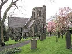 Church of St John the Baptist |
|
 Charlesworth |
|
| OS grid reference | SK005929 |
|---|---|
| District | High Peak |
| Shire county | Derbyshire |
| Region | East Midlands |
| Country | England |
| Sovereign state | United Kingdom |
| Post town | GLOSSOP |
| Postcode district | SK13 |
| Police | Derbyshire |
| Fire | Derbyshire |
| Ambulance | North West |
| EU Parliament | East Midlands |
|
|
Coordinates: 53°25′59″N 1°59′35″W / 53.433°N 1.993°W
Charlesworth is a village near Glossop, Derbyshire, England. It is located 2 miles south-west of Glossop's town centre and very close to the borders of Greater Manchester with the nearby village of Broadbottom in Tameside. The parish church of St John the Baptist was built in 1848-49. The Congregational Chapel was rebuilt from an earlier chapel in 1797. Broadbottom Bridge, one end of which is in Cheshire, was built in 1683.[1] Charlesworth holds an annual carnival on its recreation ground, which includes fell races and other events.
The village is at the foot of the "Monks' Road", which was used by the monks of Basingwerk Abbey in North Wales. At the top of the road is the Abbot's Chair, the base of a monastic cross also known as the Charlesworth Cross.
Sport
References
- ↑ Pevsner, Nikolaus. 1986. The Buildings of England:Derbyshire. page 126. Harmondsworth, Middx. Penguin.