Charlestown Township, Clark County, Indiana
| Charlestown Township | |
|---|---|
| Township | |
|
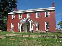
The John Work House, a historic site in the township | |
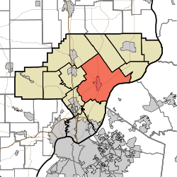 Location of Charlestown Township in Clark County | |
| Coordinates: 38°27′34″N 85°39′46″W / 38.45944°N 85.66278°WCoordinates: 38°27′34″N 85°39′46″W / 38.45944°N 85.66278°W | |
| Country | United States |
| State | Indiana |
| County | Clark |
| Government | |
| • Type | Indiana township |
| Area | |
| • Total | 65.09 sq mi (168.6 km2) |
| • Land | 64.49 sq mi (167.0 km2) |
| • Water | 0.6 sq mi (2 km2) |
| Elevation[1] | 610 ft (186 m) |
| Population (2010) | |
| • Total | 13,450 |
| • Density | 208.6/sq mi (80.5/km2) |
| FIPS code | 18-12142[2] |
| GNIS feature ID | 453197 |
Charlestown Township is one of twelve townships in Clark County, Indiana. As of the 2010 census, its population was 13,450 and it contained 5,382 housing units.[3]
History
Charlestown Township was organized in 1817.[4]
Geography
According to the 2010 census, the township has a total area of 65.09 square miles (168.6 km2), of which 64.49 square miles (167.0 km2) (or 99.08%) is land and 0.6 square miles (1.6 km2) (or 0.92%) is water.[3]
Cities and towns
Unincorporated towns
- Otisco
- Rolling Hills
- Springville (extinct)
Adjacent townships
- Oregon Township (north)
- Owen Township (east)
- Utica Township (south)
- Silver Creek Township (southwest)
- Union Township (west)
- Monroe Township (northwest)
Major highways
Cemeteries
The township contains several cemeteries: Armstrong Cemetery, Baird Cemetery (aka King), Bottorff, Caldwell (aka Lutz/Prather), Carter, Charlestown, Coble, County Poor Farm, Crace, Douglas, Faris, Fifty-four, Goodwin, Goodwin/Nicholson, Hammond, Hester-Rowland, Kessler (aka Faris II), Long, Mathes, McCormick (aka McCullough), McDonald, Meloy, Montgomery, Otisco Cemetery (aka Seedtick), Pleasant Grove, Robertson, Robinson, Salem Methodist Church, Shelby Cemetery, Silver Creek Cemetery, St. Michael's, James Stuart Plantation, Weimer, and Worrell/Worrall.[5]
References
- "Charlestown Township, Clark County, Indiana". Geographic Names Information System. United States Geological Survey. Retrieved 2009-09-24.
- United States Census Bureau cartographic boundary files
- ↑ "US Board on Geographic Names". United States Geological Survey. 2007-10-25. Retrieved 2008-01-31.
- ↑ "American FactFinder". United States Census Bureau. Retrieved 2008-01-31.
- ↑ 3.0 3.1 "Population, Housing Units, Area, and Density: 2010 - County -- County Subdivision and Place -- 2010 Census Summary File 1". United States Census. Retrieved 2013-05-10.
- ↑ Biographical and Historical Souvenir for the Counties of Clark, Crawford, Harrison, Floyd, Jefferson, Jennings, Scott, and Washington, Indiana. Chicago Printing Company. 1889. p. 9.
- ↑ Mauk, Lois. "Clark County, Indiana Cemeteries". http://www.usgennet.org/''. USGenNet. Retrieved 7 September 2014.
External links
| |||||||||||||||||||||||||||||||||