Charlestown Elevated
| Charlestown Elevated | ||||||||||||||||||||||||||||||||||||||||||||||||||||||||||||||||||||||||||||||||||||||||||||||||||||||||||||||||||||||||||||||||||||||||||||||||||||||||||||||||||||||
|---|---|---|---|---|---|---|---|---|---|---|---|---|---|---|---|---|---|---|---|---|---|---|---|---|---|---|---|---|---|---|---|---|---|---|---|---|---|---|---|---|---|---|---|---|---|---|---|---|---|---|---|---|---|---|---|---|---|---|---|---|---|---|---|---|---|---|---|---|---|---|---|---|---|---|---|---|---|---|---|---|---|---|---|---|---|---|---|---|---|---|---|---|---|---|---|---|---|---|---|---|---|---|---|---|---|---|---|---|---|---|---|---|---|---|---|---|---|---|---|---|---|---|---|---|---|---|---|---|---|---|---|---|---|---|---|---|---|---|---|---|---|---|---|---|---|---|---|---|---|---|---|---|---|---|---|---|---|---|---|---|---|---|---|---|---|---|
|
City Square station | ||||||||||||||||||||||||||||||||||||||||||||||||||||||||||||||||||||||||||||||||||||||||||||||||||||||||||||||||||||||||||||||||||||||||||||||||||||||||||||||||||||||
| Overview | ||||||||||||||||||||||||||||||||||||||||||||||||||||||||||||||||||||||||||||||||||||||||||||||||||||||||||||||||||||||||||||||||||||||||||||||||||||||||||||||||||||||
| System | BERy Main Line / MBTA Orange Line | |||||||||||||||||||||||||||||||||||||||||||||||||||||||||||||||||||||||||||||||||||||||||||||||||||||||||||||||||||||||||||||||||||||||||||||||||||||||||||||||||||||
| Termini |
Canal Street Incline Everett station | |||||||||||||||||||||||||||||||||||||||||||||||||||||||||||||||||||||||||||||||||||||||||||||||||||||||||||||||||||||||||||||||||||||||||||||||||||||||||||||||||||||
| Stations | 5 | |||||||||||||||||||||||||||||||||||||||||||||||||||||||||||||||||||||||||||||||||||||||||||||||||||||||||||||||||||||||||||||||||||||||||||||||||||||||||||||||||||||
| Operation | ||||||||||||||||||||||||||||||||||||||||||||||||||||||||||||||||||||||||||||||||||||||||||||||||||||||||||||||||||||||||||||||||||||||||||||||||||||||||||||||||||||||
| Opening | 1901 | |||||||||||||||||||||||||||||||||||||||||||||||||||||||||||||||||||||||||||||||||||||||||||||||||||||||||||||||||||||||||||||||||||||||||||||||||||||||||||||||||||||
| Closed | 1975 | |||||||||||||||||||||||||||||||||||||||||||||||||||||||||||||||||||||||||||||||||||||||||||||||||||||||||||||||||||||||||||||||||||||||||||||||||||||||||||||||||||||
| Technical | ||||||||||||||||||||||||||||||||||||||||||||||||||||||||||||||||||||||||||||||||||||||||||||||||||||||||||||||||||||||||||||||||||||||||||||||||||||||||||||||||||||||
| No. of tracks | 2 | |||||||||||||||||||||||||||||||||||||||||||||||||||||||||||||||||||||||||||||||||||||||||||||||||||||||||||||||||||||||||||||||||||||||||||||||||||||||||||||||||||||
| Track gauge | 4 ft 8 1⁄2 in (1,435 mm) | |||||||||||||||||||||||||||||||||||||||||||||||||||||||||||||||||||||||||||||||||||||||||||||||||||||||||||||||||||||||||||||||||||||||||||||||||||||||||||||||||||||
| ||||||||||||||||||||||||||||||||||||||||||||||||||||||||||||||||||||||||||||||||||||||||||||||||||||||||||||||||||||||||||||||||||||||||||||||||||||||||||||||||||||||
The Charlestown Elevated was a former segment of Boston's Orange Line rapid transit line that ran from the Canal Street Incline in parallel with the Causeway Street Elevated (near the old Boston Garden), splitting from the Causeway Elevated's right-of-way by running to the northeast around the Boston Garden, and then resuming its northwards run to the city of Everett through Charlestown. Building of the elevated began in 1899 and the first trains ran in June 1901,[1] with the Atlantic Avenue Elevated tracks splitting off to the east between North Station and City Square from the northwards turn towards Everett until the Atlantic Avenue El's own closure in 1938.
The Orange Line was rerouted to Malden via an underground route and surface-level route - the Haymarket North Extension - in 1975, the first of two major realignments of the Orange Line in the 20th century. The second realignment into metropolitan Boston's Southwest Corridor occurred in 1987, following the closure and subsequent demolition of the Washington Street Elevated that extended south of the city center. The Charlestown Elevated closed on April 4, 1975, and the new extension opened on April 7.
The Charlestown Elevated's infrastructure was demolished shortly after its closure; Sullivan Square was demolished in July 1975.[2] Remains of the bridge over the Mystic River still exist just west of the Route 99 (Alford Street) bridge, and a line of angled stone remains of the Canal Street Incline. The elevated supports can also be seen in the center span of the Charlestown Bridge. Tower C, which was located at the split between the Charlestown Elevated and the Atlantic Avenue Elevated at the southern end of the Charlestown Bridge, was moved to the Seashore Trolley Museum.[2]
Station listing
| City | Station | Notes |
|---|---|---|
| Boston | North Station | Second-floor connection to Boston Garden[2] |
| Charlestown | City Square | |
| Thompson Square | ||
| Sullivan Square | Replaced in 1975 by modern ground-level station | |
| Everett | Everett | terminal |
Gallery
-

Under construction, 1899
-

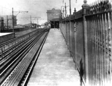
Elevated train on Canal Street Incline
-
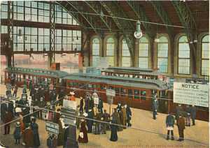
North Station elevated stop in 1922, with parallel Causeway Street Elevated streetcar tracks at left
-
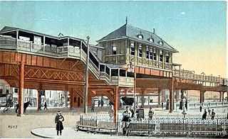
Sullivan Square, 1905
-
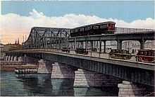
Charlestown Bridge, 1929
-
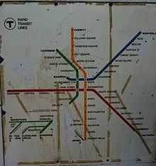
1967-69 MBTA map showing the Charlestown Elevated route
-
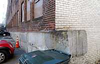
Remains of the Canal Street Incline
-

Elevated supports on Charlestown Bridge
-
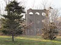
Supports at Sullivan Square
-
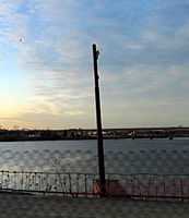
Abutment of Mystic River bridge
References
| Wikimedia Commons has media related to Charlestown Elevated. |
- ↑ "Charlestown Postcards". MIT. Retrieved 25 December 2011.
- ↑ 2.0 2.1 2.2 "Main Line Elevated Photos". Celebrate Boston. Retrieved 29 December 2011.
External links
| ||||||||||||||||||||||||||||||||||||||||||||||||||||||||||