Chappes, Allier
| Chappes | |
|---|---|
|
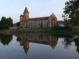
The church in Chappes | |
 Chappes | |
|
Location within Auvergne region  Chappes | |
| Coordinates: 46°23′19″N 2°55′38″E / 46.3886°N 2.9272°ECoordinates: 46°23′19″N 2°55′38″E / 46.3886°N 2.9272°E | |
| Country | France |
| Region | Auvergne |
| Department | Allier |
| Arrondissement | Montluçon |
| Canton | Montmarault |
| Intercommunality | Région de Montmarault |
| Government | |
| • Mayor (2008–2014) | Liliane Sommeiller |
| Area1 | 18.6 km2 (7.2 sq mi) |
| Population (2008)2 | 203 |
| • Density | 11/km2 (28/sq mi) |
| INSEE/Postal code | 03058 / 03390 |
| Elevation |
290–436 m (951–1,430 ft) (avg. 410 m or 1,350 ft) |
|
1 French Land Register data, which excludes lakes, ponds, glaciers > 1 km² (0.386 sq mi or 247 acres) and river estuaries. 2 Population without double counting: residents of multiple communes (e.g., students and military personnel) only counted once. | |
Chappes is a commune in the Allier department in central France.
Population
| Historical population | ||
|---|---|---|
| Year | Pop. | ±% |
| 1962 | 308 | — |
| 1968 | 352 | +14.3% |
| 1975 | 307 | −12.8% |
| 1982 | 240 | −21.8% |
| 1990 | 219 | −8.8% |
| 1999 | 221 | +0.9% |
| 2008 | 203 | −8.1% |
See also
References
| Wikimedia Commons has media related to Chappes (Allier). |