Chapinero
 Chapinero in Bogotá | |
| Area: | 38.98 km² |
|---|---|
| Population: | 122.507 (2007) |
| Type of locality: | Mixed |
| Web Page: | www.chapinero.gov.co |
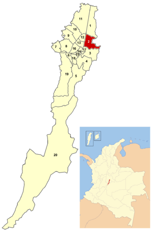
Chapinero is a locality (administrative subdivision) of Bogotá, capital of Colombia. It is located in northeastern Bogotá. It is one of the more affluent localities of the city. The boundaries are calle 39 in the south, Avenida Caracas in the west, calle 100 in the north and the eastern mountains in the east.
The Central Business District (CBD) is located between calle 72 (traditionally known as the Financial District) and calle 100. Chapinero hosts several important leisure, dining and nightlife areas of the city.
History
Chapinero was part of the thoroughfare connecting Bogotá and the northern part of the country.
The area was settled in 1812 by workers in the various industries that provided Bogotá with its day-to-day necessities. The name Chapinero comes from the shoemakers of bespoke shoes for chapines, the local expression for people suffering of pigeon toe syndrome.
Toward the end of the 1800s, the area was further settled with mansions and country estates. As the urbanized city expanded, the area was integrated accordingly. Mule-pulled trams were extended northward in 1875, followed by electric tracks in 1910.
When the Special District of Bogotá was formed in 1955, the area was made into a locality. At that time the El Lago, Chicó, and Cataluña neighborhoods were added into the locality. The physical boundaries remained the same under the reorganization into the Capital District that took place in 1991.
Together with La Candelaria and Teusaquillo, Chapinero is one of the traditional neighborhoods that is distinctive of a particular era in the city's history and urban growth. A historically upper-class neighborhood, Chapinero is famous for large areas with large, Victorian houses which reflect the influence of European architectural styles in Bogotá at the beginning of the 20th century.
Economy and Culture

Chapinero is one of the most important commercial and economic zones of the capital city. Banking and financial centers are headquartered along calle 72, carrera 7 and calle 100 with major shopping centers located along Carreras 11 and 15. Several universities are based in the locality, including the Pontificia Universidad Javeriana, Catholic University of Colombia, Universidad Piloto de Colombia, and the National Pedagogic University.
The zone also includes popular dining areas and nightlife centers, which include the Zona Rosa, the Parque de la 93, and the Zona G; the last one known for its wide offer of upscale restaurants (G stands for Gastronomy).
Chapinero is also the center of Bogotá's gay community.[1][2] There are more than 100 bars, discos and clubs that cater to the gay community in Bogotá, many of which can be found in Chapinero. The biggest and most popular gay disco in Bogotá,[3] Theatron, is located in the heart of Chapinero. Furthermore, the former mayor of Chapinero, Blanca Inés Durán Hernández, is openly lesbian.[4] The locality has a unique community center focused on the LGBT population of the neighborhood and the city. It is the first of its kind in Latin America.[5]
General information

Borders
North: Calle 100, bordering the locality of Usaquén.
East: the eastern mountains, bordering the municipalities of La Calera and Choachí.
South: Calle 39, bordering the locality of Santa Fe.
West: Avenida Caracas and Autopista Norte, with the localities of Barrios Unidos and Teusaquillo.
Points of interest
- Chicó Museum (Museo del Chicó), which includes an old manor house and a surrounding park.
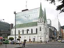
- Our Lady of Lourdes Church (Iglesia de Nuestra Señora de Lourdes)
- 93rd street park (93 Park; Parque de la 93), which is also a hotspot for upscale restaurants, bars and nightclubs.
- Shopping centers:
- Avenida de Chile, formerly known as Granahorrar
- Centro Andino
- Atlantis Plaza
- El Retiro
Transportation
Major east-west roads include Calles 39, 45, 53, 57, 63, 85, 92, 94, 100, and Avenida Chile (Calle 72). North-south routes include Carreras 7, 9, 11, 13, 15 and Avenida Caracas.
The locality is served by the Avenida Caracas line of TransMilenio, with a Carrera 7 line planned. All of the major roads have extensive private bus service.
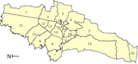
Neighborhoods
El Nogal, El Chicó, Antiguo Country, Rosales, Villa del Cerro, Chapinero Central, Chapinero Alto, La Cabrera, El Lago, El Virrey, Quinta Camacho, Pardo Rubio, Marly, La Salle, Bosque Calderón and La Porciúncula.
Before 1955, the term Chapinero included some neighborhoods that are now part of the Teusaquillo locality and did not included the El Lago, Chicó, and Cataluña neighborhoods that are currently part of the locality.
Hydrology
The rural eastern hills are heavily forested and broken up by the beginnings of several rivers, all of which flow through the locality in man-made canals. Among the more important waterways are the Río Arzobispo (Archbishop River) which joins with the San Francisco into the Río Bogotá and the Virrey that forms a part of the Salitre river system.
References
- ↑ "'El barrio más gay'" ['The most gay district'] (in Spanish). 2008-08-13. Retrieved 2012-08-29.
- ↑ "'LGBT in Colombia'". Retrieved 2012-08-29.
- ↑ "'Theatron - Uno de los mejores sitios para disfrutar de buena música y buena compañía'" [Theatron - one of the best places to enjoy good music and company] (in Spanish). Retrieved 2012-08-29.
- ↑ Gutiérrez Torres, Carolina (2008-04-25). "'Ya no me escondo en el clóset'" ['I No Longer Hide In The Closet']. El Espectador (in Spanish). Retrieved 2011-11-11.
- ↑ Gutiérrez Roa, Élber (2008-04-25). "'Ni enfermos ni animales'" ['Neither sick persons nor animals']. El Espectador (in Spanish). Retrieved 2012-08-29.
External links
- (Spanish) City of Bogota site
- (Spanish) Official Secretary of Bogotá site about Chapineiro
- (Spanish) National University of Colombia site on the locality
| ||||||||
Coordinates: 4°38′45″N 74°03′48″W / 4.64583°N 74.06333°W
ge:Chapinero