Chaparral, New Mexico
| Chaparral, New Mexico | |
|---|---|
| CDP | |
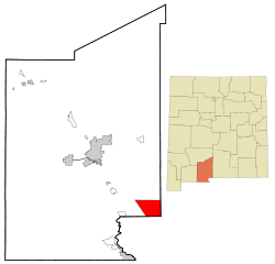 Location of Chaparral, New Mexico | |
| Coordinates: 32°2′21″N 106°25′47″W / 32.03917°N 106.42972°WCoordinates: 32°2′21″N 106°25′47″W / 32.03917°N 106.42972°W | |
| Country | United States |
| State | New Mexico |
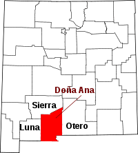
| County | Doña Ana |
| Area | |
| • Total | 38.8 sq mi (100.4 km2) |
| • Land | 38.8 sq mi (100.4 km2) |
| • Water | 0.0 sq mi (0.0 km2) |
| Elevation | 4,042 ft (1,232 m) |
| Population (2010) | |
| • Total | 14,631 |
| Time zone | Mountain (MST) (UTC-7) |
| • Summer (DST) | MDT (UTC-6) |
| ZIP codes | 88081 |
| Area code(s) | 575 |
| FIPS code | 35-14250 |
| GNIS feature ID | 0919993 |
Chaparral is a census-designated place (CDP) in Doña Ana County, New Mexico, United States. The population was 14,631 at the 2010 census.[1] A portion of Chaparral is also in Otero County, New Mexico, United States.
While there is some employment within Chaparral, Chaparral is primarily a bedroom community for the neighboring city of El Paso, Texas and the neighboring military installations of White Sands Missile Range and Fort Bliss. It is officially part of the Las Cruces Metropolitan Statistical Area.
Geography
Chaparral is located at 32°2′21″N 106°25′47″W / 32.03917°N 106.42972°W (32.039072, -106.429630)[2] and is geographically isolated from the rest of Doña Ana County, New Mexico due to its location on the east side of the Franklin Mountains.
According to the United States Census Bureau, the CDP has a total area of 38.8 square miles (100 km2), all of it land.
Growth of the community is constrained due to the border with the state of Texas on the south, the Fort Bliss Military Reservation to the east and north, as well as the Franklin Mountains and the North Franklin Mountains to the west.
Demographics
As of the census[3] of 2000, there were 6,117 people, 1,837 households, and 1,497 families residing in the CDP. The population density was 157.8 people per square mile (60.9/km2). There were 2,134 housing units at an average density of 55.1 per square mile (21.3/km2). The racial makeup of the CDP was 70.69% White, 1.26% African American, 1.29% Native American, 0.43% Asian, 0.18% Pacific Islander, 21.38% from other races, and 4.77% from two or more races. Hispanics or Latinos of any race were 64.49% of the population.
There were 1,837 households out of which 48.9% had children under the age of 18 living with them, 62.6% were married couples living together, 14.1% had a female householder with no husband present, and 18.5% were non-families. 15.6% of all households were made up of individuals and 5.2% had someone living alone who was 65 years of age or older. The average household size was 3.32 and the average family size was 3.70.
In the CDP the population was spread out with 36.2% under the age of 18, 9.1% from 18 to 24, 28.6% from 25 to 44, 18.9% from 45 to 64, and 7.1% who were 65 years of age or older. The median age was 29 years. For every 100 females there were 101.1 males. For every 100 females age 18 and over, there were 95.1 males.
The median income for a household in the CDP was $22,692, and the median income for a family was $26,153. Males had a median income of $23,904 versus $17,750 for females. The per capita income for the CDP was $10,033. About 25.2% of families and 31.3% of the population were below the poverty line, including 42.6% of those under age 18 and 24.8% of those age 65 or over.
Education
As part of the Gadsden Independent School District, Chaparral has the following public schools:
- Elementary Schools
- Chaparral Elementary School
- Desert Trail Elementary School
- Sunrise Elementary School
- Middle Schools
- Chaparral Middle School
- High Schools
- Chaparral High School
Doña Ana Community College also maintains a satellite campus in Chaparrel.
Transportation
Commercial air and rail transportation are available in the neighboring city of El Paso, Texas. Several highways (state and federal) pass through Chaparral:
- NM 213, which runs north-south connecting El Paso to White Sands Missile Range. In Chaparral it is known as War Highway (which refers to its construction during World War II as a military access road) and connects to Martin Luther King Boulevard (Texas Farm-to-Market Road 3255) in El Paso.
- NM 404, which runs east-west. This highway connects Chaparral to Anthony, New Mexico and Interstate 10, which is approximately 10 miles to the west through the Anthony Gap. In both Anthony and Chaparral it is known as O'Hara Road.
- U.S. Route 54, which runs north-south along Chaparral's eastern border, connects to Dyer Street and the Patriot Freeway in El Paso.
Town Highlights
- Chaparral High School
- Dolores Wright Park
- Chaparral Taekwondo Academy
References
- ↑ "American FactFinder". Factfinder2.census.gov. Retrieved 2012-08-13.
- ↑ "US Gazetteer files: 2010, 2000, and 1990". United States Census Bureau. 2011-02-12. Retrieved 2011-04-23.
- ↑ "American FactFinder". United States Census Bureau. Retrieved 2008-01-31.
| |||||||||||||||||||||||||||||||||