Chaos Reef
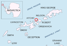 Location of Aitcho Islands in the South Shetland Islands. | |
| Geography | |
|---|---|
| Location | Antarctica |
| Coordinates | 62°21′50.6″S 59°46′11″W / 62.364056°S 59.76972°W |
| Archipelago | South Shetland Islands |
| Country | |
| Demographics | |
| Population | 0 |
| Additional information | |
| Administered under the Antarctic Treaty System | |

Chaos Reef is the confused area of breakers and shoal water in the north extremity of Aitcho Islands group on the west side of English Strait in the South Shetland Islands, Antarctica. The area was visited by early 19th century sealers operating from nearby Clothier Harbour.
Following a survey by the 1949 Chilean Antarctic Expedition, the feature was resurveyed and descriptively named from HMS Protector in 1967.
Location
The reef is located at 62°21′50.6″S 59°46′11″W / 62.364056°S 59.76972°W which is 970 m (1,061 yd) north-northwest from the midpoint of Okol Rocks, 1.13 km (0.70 mi) north-northeast of Kilifarevo Island, 1.48 km (0.92 mi) east-northeast of Morris Rock, 1.26 km (0.78 mi) southeast of Turmoil Rock, 3.96 km (2.46 mi) southwest of Cornwall Island and 2.45 km (1.52 mi) west-northwest of Fort William, Robert Island (Chilean mapping in 1949-50 and 1971, British in 1968, 1972 and 1990, and Bulgarian in 2009).
See also
- Composite Antarctic Gazetteer
- List of Antarctic and sub-Antarctic islands
- List of Antarctic islands south of 60° S
- SCAR
- Territorial claims in Antarctica
Maps
- L.L. Ivanov. Antarctica: Livingston Island and Greenwich, Robert, Snow and Smith Islands. Scale 1:120000 topographic map. Troyan: Manfred Wörner Foundation, 2009. ISBN 978-954-92032-6-4