Chantelle, Allier
| Chantelle | ||
|---|---|---|
|
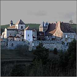
The abbey in Chantelle | ||
| ||
 Chantelle | ||
|
Location within Auvergne region  Chantelle | ||
| Coordinates: 46°14′20″N 3°09′14″E / 46.2389°N 3.1539°ECoordinates: 46°14′20″N 3°09′14″E / 46.2389°N 3.1539°E | ||
| Country | France | |
| Region | Auvergne | |
| Department | Allier | |
| Arrondissement | Moulins | |
| Canton | Chantelle | |
| Intercommunality | Pays Saint-Pourcinois | |
| Government | ||
| • Mayor (2014–2020) | André Bidaud (PR) | |
| Area1 | 10.96 km2 (4.23 sq mi) | |
| Population (2008)2 | 1,062 | |
| • Density | 97/km2 (250/sq mi) | |
| INSEE/Postal code | 03053 / 03140 | |
| Elevation |
258–349 m (846–1,145 ft) (avg. 324 m or 1,063 ft) | |
|
1 French Land Register data, which excludes lakes, ponds, glaciers > 1 km² (0.386 sq mi or 247 acres) and river estuaries. 2 Population without double counting: residents of multiple communes (e.g., students and military personnel) only counted once. | ||
.svg.png)
Chantelle is a commune in the Allier department in central France.
Geography
The village lies on the right bank of the Bouble, which forms most of the commune's northern border.
Population
| Historical population | ||
|---|---|---|
| Year | Pop. | ±% |
| 1962 | 1,095 | — |
| 1968 | 1,121 | +2.4% |
| 1975 | 1,069 | −4.6% |
| 1982 | 1,084 | +1.4% |
| 1990 | 1,043 | −3.8% |
| 1999 | 1,040 | −0.3% |
| 2008 | 1,062 | +2.1% |
See also
References
External links
| Wikimedia Commons has media related to Chantelle. |
- Official Web site (in French)