Channel Light Vessel Automatic
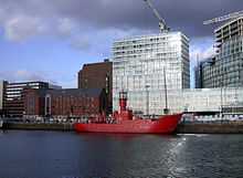 Channel lightvessel 23 at Canning Dock | |
| Career (UK) | |
|---|---|
| Operator: | Trinity House |
| In service: | 25th November 2006 |
| General characteristics | |
| Type: | Lightvessel |
 Channel Light Vessel | |
| Coordinates | 49°54.459′N 2°53.744′W / 49.907650°N 2.895733°WCoordinates: 49°54.459′N 2°53.744′W / 49.907650°N 2.895733°W |
|---|---|
| Focal height | 12 m (39 ft) |
| Range | 15 mi (24 km) |
| Characteristic | F0.3 15s |
| Fog signal | 1 blast of 2 seconds every 20 seconds |
| Managing agent | Trinity House |
Channel Light Vessel Automatic is the name of a lightvessel in the English Channel. It is one of the 22 coastal weather stations whose conditions are automatically reported in the BBC Shipping Forecast. The vessel's position is 49°55′N 2°54′W / 49.917°N 2.900°W, approximately 56 km (35 mi) north-northwest of Guernsey.
The lightvessel marks the western end of the English Channel Traffic Separation Zone.[1]
Signals
The light, on a 12 m (39 ft) tower, has a range of about 15 miles, and flashes for .3 seconds every 15 seconds. The fog signal gives a single 2 second blast every 20 seconds. The agile radio beacon transmits the letter "O" in morse code on X band and S band frequencies for nine seconds every thirty seconds.[2]
References
- ↑ Trinity House Information
- ↑ "NOTICE TO MARINERS No.66/06". Trinity House. 30 October 2006. Retrieved 19 June 2012.