Changtu County
| Changtu County 昌图县 | |
|---|---|
| County | |
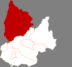 Location in Tieling City | |
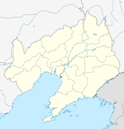 Changtu Location in Liaoning | |
| Coordinates: 42°47′N 124°07′E / 42.783°N 124.117°ECoordinates: 42°47′N 124°07′E / 42.783°N 124.117°E | |
| Country | People's Republic of China |
| Province | Liaoning |
| Prefecture-level city | Tieling |
| County seat | Changtu Town (昌图镇) |
| Area | |
| • Total | 4,321.7 km2 (1,668.6 sq mi) |
| Elevation | 152 m (499 ft) |
| Time zone | China Standard (UTC+8) |
| Postal code | 110400 |
Changtu County (simplified Chinese: 昌图县; traditional Chinese: 昌圖縣; pinyin: Chāngtú Xiàn) is a county in the northeast of Liaoning province, China, bordering Jilin to the northeast and Inner Mongolia in the northwest. It is under the administration of Tieling City, the downtown of which lies 60 kilometres (37 mi) to the south-southwest, and is 47 kilometres (29 mi) southwest of Siping, Jilin. It is served by both China National Highway 102 and G1 Beijing–Harbin Expressway.
Administrative Divisions
There are 23 towns and 10 townships under the county's administration.[1]
Towns:
|
|
|
Townships:
- Daxing Township (大兴乡)
- Shibajiazi Township (十八家子乡)
- Tongjiangkou Township (通江口乡)
- Dasijiazi Township (大四家子乡)
- Houyao Township (后窑乡)
- Changfa Township (长发乡)
- Taiping Township (太平乡)
- Xia'ertai Township (下二台乡)
- Ping'anbao Township (平安堡乡)
- Qujiadian Township (曲家店乡)
References
- ↑ 2011年统计用区划代码和城乡划分代码:昌图县 (in Chinese). National Bureau of Statistics of the People's Republic of China. Retrieved 2012-07-17.
External links
| ||||||||||||||||||||||||||||||||||||||||||||||||||||||||||||||||||||||