Changhai County
| Changhai County 长海县 | |||||||||||||||||||||||||||||||
|---|---|---|---|---|---|---|---|---|---|---|---|---|---|---|---|---|---|---|---|---|---|---|---|---|---|---|---|---|---|---|---|
| County | |||||||||||||||||||||||||||||||
 Changhai Location in Liaoning | |||||||||||||||||||||||||||||||
| Coordinates: 39°16′19″N 122°35′42″E / 39.272°N 122.595°ECoordinates: 39°16′19″N 122°35′42″E / 39.272°N 122.595°E[1] | |||||||||||||||||||||||||||||||
| Country |
| ||||||||||||||||||||||||||||||
| Province | Liaoning | ||||||||||||||||||||||||||||||
| Sub-provincial city | Dalian | ||||||||||||||||||||||||||||||
| Area[2] | |||||||||||||||||||||||||||||||
| • Total | 156.89 km2 (60.58 sq mi) | ||||||||||||||||||||||||||||||
| Population (2010)[3] | |||||||||||||||||||||||||||||||
| • Total | 77,951 | ||||||||||||||||||||||||||||||
| • Density | 500/km2 (1,300/sq mi) | ||||||||||||||||||||||||||||||
| Time zone | China Standard (UTC+8) | ||||||||||||||||||||||||||||||
| Postal code | 1165XX | ||||||||||||||||||||||||||||||
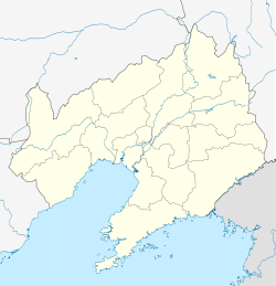
| Dalian district map | |||||||||||||||||||||||||||||||
| |||||||||||||||||||||||||||||||
Changhai County (simplified Chinese: 长海县; traditional Chinese: 長海縣; pinyin: Chánghǎi Xiàn; literally: "long sea") is under the administration of Dalian, Liaoning province, People's Republic of China. It consists of several islands in the Yellow Sea and is located offshore of the Liaodong Peninsula. There are 112 small islands and reefs in the county, traditionally called the Outer Chang Mountains Island Chain. Its area is 156.89 square kilometres (60.58 sq mi) and its permanent population as of 2010 is 77,951, making it Dalian's least populous county-level division,[2][3] and the county government is located in the Dongshan neighborhood of the town of Dachangshandao.
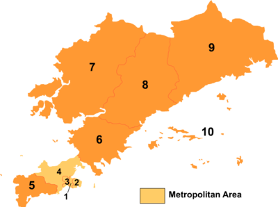
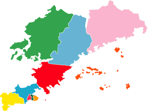
Administrative divisions
There are 2 towns and 3 township in the county.[4]
Towns:
- Dachangshandao (大长山岛镇), Zhangzidao (獐子岛镇)
Townships:
- Guanglu Township (广鹿乡), Haiyang Township (海洋乡), Xiaochangshan Township (小长山乡)
Gallery
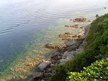 Xiaoshuikou (小水口) in Xiaochangshan Island, Changhai County |
References
External links
| ||||||||||||||||||||||||||||||||||||||||||||||||||||||||||||||||||||||
| |||||||||||||||||||||||||||||||||||||