Chamrousse
| Chamrousse | |
|---|---|
|
Part of the ski area, viewed from Recoin | |
 Chamrousse | |
|
Location within Rhône-Alpes region  Chamrousse | |
| Coordinates: 45°06′33″N 5°52′28″E / 45.1092°N 5.8744°ECoordinates: 45°06′33″N 5°52′28″E / 45.1092°N 5.8744°E | |
| Country | France |
| Region | Rhône-Alpes |
| Department | Isère |
| Arrondissement | Grenoble |
| Canton | Domène and Vizille |
| Intercommunality | Pays du Grésivaudan |
| Government | |
| • Mayor (2014–2020) | Philippe Cordon |
| Area1 | 13 km2 (5 sq mi) |
| Population (2009)2 | 459 |
| • Density | 35/km2 (91/sq mi) |
| INSEE/Postal code | 38567 / 38410 |
| Elevation | 1,384–2,440 m (4,541–8,005 ft) |
|
1 French Land Register data, which excludes lakes, ponds, glaciers > 1 km² (0.386 sq mi or 247 acres) and river estuaries. 2 Population without double counting: residents of multiple communes (e.g., students and military personnel) only counted once. | |
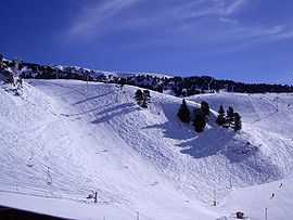
Chamrousse is a ski resort in southeastern France, in the Belledonne Mountain Range near Grenoble in the Isère department. It is located in a commune of the same name and is situated on the Recoin at 1,650 m (5,413 ft) and the Roche Béranger at 1,750 m (5,741 ft). The ski-lifts reach the Cross of Chamrousse at 2,253 m (7,392 ft).
Population
| Historical population | ||
|---|---|---|
| Year | Pop. | ±% |
| 1975 | 533 | — |
| 1982 | 607 | +13.9% |
| 1990 | 544 | −10.4% |
| 1999 | 518 | −4.8% |
| 2011 | 460 | −11.2% |
Olympics
Chamrousse hosted the six alpine skiing events at the 1968 Winter Olympics, where Jean-Claude Killy of France won three gold medals in the men's events. All women's events took place at Recoin de Chamrousse, located 2 km (1.2 mi) away.[1]
Skiing at Chamrousse
There are more than 90 km (56 mi) of downhill runs at Chamrousse and 24 ski lifts. There are also 37 km (23 mi) of trails for cross-country skiing. Cross-country skiing can be practised from the opening of the resort to early or mid-April.
Cycle racing
Details of the climb
The road to the ski station starts at Uriage-les-Bains from where the climb is 19 km (12 mi) long, gaining 1,235 m (4,052 ft) in altitude, at an average gradient of 6.5%. There are several sections in excess off 11% in the early stages of the climb.[2] For the Tour de France, the summit is at an altitude of 1,730 m (5,680 ft).[3]
The ski station can also be reached by a more northerly route, from Uriage-les-Bains via Saint-Martin-d'Uriage. This climb is 18.2 km (11.3 mi) gaining 1,315 m (4,314 ft) in altitude, at an average gradient of 7.2%.[4]
Tour de France
The climb of Chamrousse was used in the mountain time-trial in the 2001 Tour de France. Lance Armstrong won the stage (#11) on 18 July 2001,[3] when he took just over an hour to complete the hors categorie climb from Grenoble to the ski resort. In 2012, Armstrong was disqualified from winning this stage, following the Lance Armstrong doping case.[3]
The ski station was re-visited by the race on 18 July 2014.[5] The winner of the 197 km (122 mi) stage 13 from Saint-Étienne was the Italian Vincenzo Nibali who increased his lead over his nearest rivals, with Richie Porte, who began the day second overall, losing nine minutes on the climb.[6]
References
- ↑ 1968 Winter Olympics official report. pp. 77-84. (English) & (French)
- ↑ "Chamrousse - Sud - Uriage les Bains". climbbybike. Retrieved 18 July 2014.
- ↑ 3.0 3.1 3.2 "Chamrousse dans le Tour de France" (in French). ledicodutour. Retrieved 18 July 2014.
- ↑ "Chamrousse - Uriage les Bains". climbbybike. Retrieved 19 July 2014.
- ↑ "Stage 13: Saint-Étienne to Chamrousse". Tour de France. Amaury Sport Organisation. Retrieved 18 July 2014.
- ↑ "Tour de France: Vincenzo Nibali wins stage 13 to extend lead". BBC Sport. 18 July 2014. Retrieved 19 July 2014.
External links
| Wikimedia Commons has media related to Chamrousse. |
- Official website (French)
- guide web touristique (French)
- INSEE statistics
| ||||||
| ||||||||