Champdieu
| Champdieu | ||
|---|---|---|
|
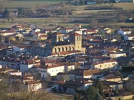
The church and surrounding buildings in Champdieu | ||
| ||
 Champdieu | ||
|
Location within Rhône-Alpes region  Champdieu | ||
| Coordinates: 45°38′44″N 4°02′46″E / 45.6456°N 4.0461°ECoordinates: 45°38′44″N 4°02′46″E / 45.6456°N 4.0461°E | ||
| Country | France | |
| Region | Rhône-Alpes | |
| Department | Loire | |
| Arrondissement | Montbrison | |
| Canton | Montbrison | |
| Intercommunality | Communauté d'agglomération Loire Forez | |
| Government | ||
| • Mayor (2008–2014) | Patrice Couchaud | |
| Area1 | 18.2 km2 (7.0 sq mi) | |
| Population (2008)2 | 1,651 | |
| • Density | 91/km2 (230/sq mi) | |
| INSEE/Postal code | 42046 / 42600 | |
| Elevation |
363–727 m (1,191–2,385 ft) (avg. 398 m or 1,306 ft) | |
|
1 French Land Register data, which excludes lakes, ponds, glaciers > 1 km² (0.386 sq mi or 247 acres) and river estuaries. 2 Population without double counting: residents of multiple communes (e.g., students and military personnel) only counted once. | ||
.svg.png)
Champdieu is a commune in the Loire department in central France.
History
The town and name of Champdieu evolved in the course of ages. First of all CANDICUS (Roman leader), then in the 11th century the village is called CANDIACO. It becomes in the 13th century CHANDIACO then CHANDIEU and becoming in the 16th century into "FIELD-GOD" expression in French to finally in 1801 to be registered CHAMPDIEU.
CASTRUM CANDIACO
"Sunt autem ipsæ res site in pago Lugdunense, in agro Candiacense, in villa et Castrum Candiaco dei Baronum Candiæ" Latin inscription in the land registry of the Castle and baronny of Candia.
The origin of the village parried be previous to Carolingian times.
See also
References
| Wikimedia Commons has media related to Champdieu. |