Chame, Nepal
| Chame चाँमे | |
|---|---|
| Municipality | |
 | |
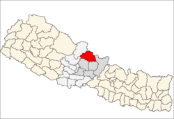
 Chame Location in Nepal | |
| Coordinates: 28°33′7″N 84°14′27″E / 28.55194°N 84.24083°ECoordinates: 28°33′7″N 84°14′27″E / 28.55194°N 84.24083°E | |
| Country |
|
| Zone | Gandaki Zone |
| District | Manang District |
| Elevation | 2,650 m (8,690 ft) |
| Population (2001) | |
| • Total | 1,204 |
| Time zone | Nepal Time (UTC+5:45) |
Chame (Nepali: चाँमे) is the headquarters of Manang District in the Gandaki Zone of northern Nepal.[1] At the time of the 2001 Nepal census it had a population of 1204 people living in 278 individual households. Manang District is the lowest populated district in Nepal.[2]
2015 Nepal earthquake
The village was affected by an earthquake on 25 April 2015. Reports from the area indicate that the roads and buildings of the village are damaged.[3]
References
- ↑ Districts of Nepal - Statoids
- ↑ "Nepal Census 2001", Nepal's Village Development Committees (Digital Himalaya), retrieved 15 November 2009.
- ↑ Amey, Ben (27 April 2015). "Delmar doctor stranded in Nepal after earthquake". WNYT.com. WNYT.com. Archived from the original on 1 May 2015. Retrieved 1 May 2015.
| |||||||||||||