Chambon-sur-Voueize
| Chambon-sur-Voueize | ||
|---|---|---|
|
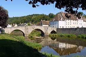
The Romanesque bridge in Chambon-sur-Voueize | ||
| ||
 Chambon-sur-Voueize | ||
|
Location within Limousin region  Chambon-sur-Voueize | ||
| Coordinates: 46°11′24″N 2°25′33″E / 46.19°N 2.4258°ECoordinates: 46°11′24″N 2°25′33″E / 46.19°N 2.4258°E | ||
| Country | France | |
| Region | Limousin | |
| Department | Creuse | |
| Arrondissement | Aubusson | |
| Canton | Chambon-sur-Voueize | |
| Intercommunality | Évaux-les-Bains Chambons-sur-Voueize | |
| Government | ||
| • Mayor (2008–2014) | Cécile Creuzon | |
| Area1 | 33.58 km2 (12.97 sq mi) | |
| Population (2008)2 | 1,014 | |
| • Density | 30/km2 (78/sq mi) | |
| INSEE/Postal code | 23045 / 23170 | |
| Elevation | 320–510 m (1,050–1,670 ft) | |
|
1 French Land Register data, which excludes lakes, ponds, glaciers > 1 km² (0.386 sq mi or 247 acres) and river estuaries. 2 Population without double counting: residents of multiple communes (e.g., students and military personnel) only counted once. | ||

Chambon-sur-Voueize is a commune in the Creuse department in the Limousin region in central France.
Geography
An area of lakes, forestry and farming comprising a small town and several hamlets, situated at the confluence of the rivers Voueize and Tardes, some 10 miles (16 km) southwest of Montlucon near the junction of the D915, D917 and the D993 roads.
Population
| Historical population | ||
|---|---|---|
| Year | Pop. | ±% |
| 1962 | 1,276 | — |
| 1968 | 1,367 | +7.1% |
| 1975 | 1,206 | −11.8% |
| 1982 | 1,288 | +6.8% |
| 1990 | 1,105 | −14.2% |
| 1999 | 1,012 | −8.4% |
| 2008 | 1,014 | +0.2% |
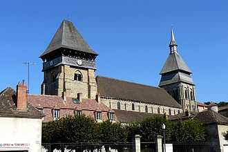
The church of Sainte-Valérie
Sights
- The abbey church of St. Valerie, dating from the eleventh century.
- The château de Marsat.
- The ruined castle at Barbe-Bleu.
- A medieval bridge over the Voueize.
See also
References
External links
| Wikimedia Commons has media related to Chambon-sur-Voueize. |