Chamblet
| Chamblet | |
|---|---|
|
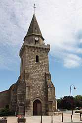
The church in Chamblet | |
 Chamblet | |
|
Location within Auvergne region  Chamblet | |
| Coordinates: 46°20′01″N 2°42′11″E / 46.3336°N 2.7031°ECoordinates: 46°20′01″N 2°42′11″E / 46.3336°N 2.7031°E | |
| Country | France |
| Region | Auvergne |
| Department | Allier |
| Arrondissement | Montluçon |
| Canton | Montluçon-Est |
| Intercommunality | Commentry–Néris-les-Bains |
| Government | |
| • Mayor (2008–2014) | Alain Chanier |
| Area1 | 20.5 km2 (7.9 sq mi) |
| Population (2008)2 | 1,066 |
| • Density | 52/km2 (130/sq mi) |
| INSEE/Postal code | 03052 / 03170 |
| Elevation |
279–393 m (915–1,289 ft) (avg. 350 m or 1,150 ft) |
|
1 French Land Register data, which excludes lakes, ponds, glaciers > 1 km² (0.386 sq mi or 247 acres) and river estuaries. 2 Population without double counting: residents of multiple communes (e.g., students and military personnel) only counted once. | |
Chamblet is a commune in the Allier department in central France.
Population
| Historical population | ||
|---|---|---|
| Year | Pop. | ±% |
| 1962 | 792 | — |
| 1968 | 855 | +8.0% |
| 1975 | 807 | −5.6% |
| 1982 | 932 | +15.5% |
| 1990 | 1,046 | +12.2% |
| 1999 | 941 | −10.0% |
| 2008 | 1,066 | +13.3% |
See also
References
| Wikimedia Commons has media related to Chamblet. |