Challwa
| Challwa | |
|---|---|
| Wiksu | |
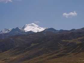 Challwa (on the left) and Tuku as seen from the south (Aquia District) | |
| Elevation | 5,487 m (18,002 ft)[1] |
| Location | |
 Challwa Peru | |
| Location | Peru, Ancash Region |
| Range | Cordillera Blanca |
| Coordinates | 9°55′15″S 77°13′23″W / 9.92083°S 77.22306°WCoordinates: 9°55′15″S 77°13′23″W / 9.92083°S 77.22306°W |
| Climbing | |
| First ascent | 1-1959 via N.W. ridge.[1] |
Challwa (Quechua for "fish",[2] hispanicized spellings Chalhua, Challhua) or Wiksu (Quechua for "twisted, bent", hispanicized Huicsu, also Huicsa, Wiksa means "stomach")[2] is a mountain in the southern Cordillera Blanca in the Andes of Peru, about 5,487 m (18,002 ft)) high. Challwa is located in the Ancash Region, Bolognesi Province, Aquia District and in the Recuay Province, Catac District.[3][4][5] It is situated northeast of Qiwllarahu, west of Pastu Ruri and Tuku and south of Santun. One of the nearest places is Wiksu (Wicsu) west of the mountain. The village lies in the Wiksu ravine (Huicso, also Callan). Its stream flows to the river Pumapampa (Pachaqutu), a right affluent of the Santa River.
Sources
- ↑ 1.0 1.1 Taken from Mountaineering in the Andes by Jill Neate Peru RGS-IBG Expedition Advisory Centre, 2nd edition, May 1994
- ↑ 2.0 2.1 Teofilo Laime Ajacopa, Diccionario Bilingüe Iskay simipi yuyayk'ancha, La Paz, 2007 (Quechua-Spanish dictionary)
- ↑ ^ escale.minedu.gob.pe - UGEL map of the Bolognesi Province (Ancash Region)
- ↑ andix.com Map of a part of the Cordillera Blanca
- ↑ John Biggar, The Andes: A Guide for Climbers, see sketch map on p. 90