Chaeryong County
| Chaeryong County 재령군 | |
|---|---|
| County | |
| Korean transcription(s) | |
| • Hanja | 載寧郡 |
| • McCune-Reischauer | Chaeryŏng-gun |
| • Revised Romanization | Jaeryeong-gun |
 | |
| Country | North Korea |
| Province | South Hwanghae Province |
| Administrative divisions | 1 ŭp, 1 rodongjagu, 24 ri |
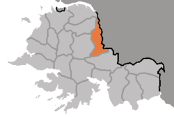
Chaeryŏng County is a county in South Hwanghae province, North Korea.
Geography
Located on the Chaeryŏng River, the county is bordered to the west by Anak and Sinch'ŏn, to the south by Sinwŏn, and to the east by Ŭnp'a, Pongsan and Sariwŏn in North Hwanghae Province.
History
Chaeryŏng County was first founded by the kingdom of Koguryo, who called it Siksŏng (息城郡). Koguryo lost the area during the unification of Korea by the Koryo dynasty, who gave it its current name in 1217. In 1415 it was promoted to county level under the Yi. Chaeryŏng was briefly merged into the newly formed Hwanghae District in 1895 during an experimental redistricting, but was restored to its previous form in 1896. The county's current form was settled in the 1952 redistricting changes.
Transportation
The county is served by railway Line, which stops at Chaeryŏng and Kumsan Stations. There is also a highway which runs through Chaeryŏng Town.
Divisions
The county is divided into one town (ŭp), one worker's district (rodongjagu) and 24 villages (ri). [1]
| Chosŏn'gŭl | Hancha | |
|---|---|---|
| Chaeryŏng Town | 재령읍 | 載寧邑 |
| Kŭmsan Worker's District | 금산노동자구 | 金山勞動者區 |
| Chaech'ŏn | 재천리 | 財泉里 |
| Changguk-ri | 장국리 | 墻菊里 |
| Ch'ŏngch'ŏn-ri | 청천리 | 清川里 |
| Ch'ŏnma-ri | 천마리 | 川磨里 |
| Kanggyo-ri | 강교리 | 江橋里 |
| Kimjewŏn-ri | 김제원리 | 金濟元里 |
| Kosan-ri | 고산리 | 孤山里 |
| Kulhae-ri | 굴해리 | 屈海里 |
| Namji-ri | 남지리 | 南芝里 |
| Pongch'ŏn-ri | 봉천리 | 蓬泉里 |
| Pongo-ri | 봉오리 | 鳳梧里 |
| Pudŏk-ri | 부덕리 | 富德里 |
| Pukji-ri | 북지리 | 北芝里 |
| Pyŏksan-ri | 벽산리 | 碧山里 |
| Naerim-ri | 래림리 | 來臨里 |
| Ryonggyo-ri | 룡교리 | 龍橋里 |
| Samjigang-ri | 삼지강리 | 三支江里 |
| Singot-ri | 신곶리 | 新串里 |
| Sinhwanp'o-ri | 신환포리 | 新換浦里 |
| Sŏkt'an-ri | 석탄리 | 石灘里 |
| Sŏrim-ri | 서림리 | 西林里 |
| Sŏwŏn-ri | 서원리 | 書院里 |
| Tongsinhung-ri | 동신흥리 | 東新興里 |
| Yanggye-ri | 양계리 | 陽溪里 |
People born in Chaeryŏng
- Choi Eun-Taek (1938-2007), South Korean football coach
See also
References
| ||||||||||||||||
