Ch'iqun
| Ch'iqun | |
|---|---|
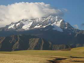 Ch'iqun as seen from the south west | |
| Elevation | 5,530 m (18,140 ft)[1] |
| Location | |
 Ch'iqun Peru | |
| Location | Peru |
| Range | Andes, Urupampa |
| Coordinates | 13°14′12″S 72°03′22″W / 13.23667°S 72.05611°WCoordinates: 13°14′12″S 72°03′22″W / 13.23667°S 72.05611°W |
| Climbing | |
| First ascent | 1-1958: Via prominent snow gully on S.face & ridge[2] |
Ch'iqun (Quechua ch'iqu workable stone, hispanicized spellings Chicon, Chicón) is a mountain in the Urupampa mountain range in the Andes of Peru, about 5,530 m (17,713 ft) high. It is located in the Cusco Region, Calca Province, Calca District and in the Urubamba Province, Urubamba District. It is situated north east of the town Yucay, south east of the Pumawanka and south west of the Siriwani.[3]
External links
![]() Media related to Ch'iqun at Wikimedia Commons
Media related to Ch'iqun at Wikimedia Commons
References
- ↑ siar.regioncusco.gob.pe
- ↑ Jill Neate, Mountaineering in the Andes, 1994
- ↑ allthemountains.com Map of the Urupampa mountain range