Ch'ila mountain range
| Ch'ila mountain range | |
|---|---|
|
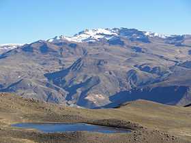
Mismi behind the lake Limaquta | |
| Highest point | |
| Peak | Ch'ila |
| Elevation | 5,654 m (18,550 ft) |
| Dimensions | |
| Length | 80 km (50 mi) N-S |
| Geography | |
| Country | Peru |
| State/Province | Arequipa Region |
| Parent range | Andes |
The Ch'ila mountain range (Quechua ch'ila hard, very resistant,[1] also spelled Chila) lies in the Arequipa Region in the Andes of Peru. It extends between 15°02' and 15°26'S and 71°43' and 72°37'W for about 80 km.[2] The range is located in the provinces Castilla and Caylloma.
Mountains
The highest mountain in the range is Ch'ila at 5,654 metres (18,550 ft). Other notable peaks are:[3][4][5][6]
- Asnu Wañusqa (Asnohuanusja, Asnohuañusca)
- Chinchun (Chinchon)
- Chuqipirwa, 5,400 metres (17,717 ft)
- Hatunpila, 5,450 metres (17,881 ft)
- Kiskap'anqa (Quiscapanca), 5,400 metres (17,717 ft)
- Kiwicha 5,514 metres (18,091 ft)
- Minaspata, 5,555 metres (18,225 ft)
- Mismi, 5,597 metres (18,363 ft)
- Pukara, 5,000 metres (16,404 ft)
- Q'asiri, 5,647 metres (18,527 ft)
- Sirani, 5,229 metres (17,156 ft)
- Suriwiri, 5,506 metres (18,064 ft)
- Wamanripayuq (Huamanripayoc) and
- Yuraq Q'asa, 5,456 metres (17,900 ft).
References
- ↑ Teofilo Laime Ajacopa, Diccionario Bilingüe Iskay simipi yuyayk'ancha, La Paz, 2007 (Quechua-Spanish dictionary)
- ↑ usgs.gov USGS, Peruvian Cordilleras
- ↑ Taken from Mountaineering in the Andes by Jill Neate RGS-IBG Expedition Advisory Centre, 2nd edition, May 1994
- ↑ lib.utexas.edu Map of the area
- ↑ allthemountains.com
- ↑ escale.minedu.gob.pe - UGEL map of the Caylloma Province 1 (Arequipa Region)