Chūō-ku, Sagamihara
| Chūō 中央区 | |
|---|---|
| Ward of Sagamihara | |
| 中央区 • Chūō-ku | |
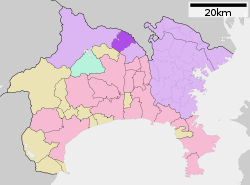 Map of Chūō-ku, Sagamihara | |
 Chūō
| |
| Coordinates: 35°34′17″N 139°22′24″E / 35.57139°N 139.37333°ECoordinates: 35°34′17″N 139°22′24″E / 35.57139°N 139.37333°E | |
| Country | Japan |
| Region | Kantō |
| Prefecture | Kanagawa |
| City | Sagamihara |
| Area | |
| • Total | 36.8 km2 (14.2 sq mi) |
| Population (March 1, 2010) | |
| • Total | 265,057 |
| • Density | 7,202/km2 (18,650/sq mi) |
| Time zone | Japan Standard Time (UTC+9) |
| Phone number | 042-769-9802 |
| Address | 11-15, Chūō 2-chōme Chūō-ku, Sagamihara-shi Kanagawa-ken 252-5277 |
| Website | Chūō-ku home page |

Sagamihara City Hall, also housing Chūō-ku Ward Office
Chūō-ku (中央区 Chūō-ku) is one of three wards of Sagamihara, Kanagawa, Japan, located in the central part of the city. The north west of Chūō-ku faces Midori-ku; the south east faces Minami-ku; the north faces Machida.
Chūō-ku was created on April 1, 2010 when Sagamihara became a city designated by government ordinance (a "designated city").
As of March 2010, Chūō-ku had a population of 265,057, with a land area of 36.8 square kilometers.
| Wikimedia Commons has media related to Chuo-ku, Sagamihara. |
| ||||||||||||||||||||||||||||||||||||||||||||||||||||||