Châtel-Montagne
| Châtel-Montagne | ||
|---|---|---|
|
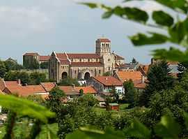
The church and surrounding buildings in Châtel-Montagne | ||
| ||
 Châtel-Montagne | ||
|
Location within Auvergne region  Châtel-Montagne | ||
| Coordinates: 46°06′50″N 3°41′01″E / 46.1139°N 3.6836°ECoordinates: 46°06′50″N 3°41′01″E / 46.1139°N 3.6836°E | ||
| Country | France | |
| Region | Auvergne | |
| Department | Allier | |
| Arrondissement | Vichy | |
| Canton | Le Mayet-de-Montagne | |
| Intercommunality | Montagne Bourbonnaise | |
| Government | ||
| • Mayor (2008–2014) | Michel Etien | |
| Area1 | 36.81 km2 (14.21 sq mi) | |
| Population (2008)2 | 419 | |
| • Density | 11/km2 (29/sq mi) | |
| INSEE/Postal code | 03066 / 03250 | |
| Elevation |
331–972 m (1,086–3,189 ft) (avg. 530 m or 1,740 ft) | |
|
1 French Land Register data, which excludes lakes, ponds, glaciers > 1 km² (0.386 sq mi or 247 acres) and river estuaries. 2 Population without double counting: residents of multiple communes (e.g., students and military personnel) only counted once. | ||

Châtel-Montagne is a commune in the Allier department in central France.
Population
| Historical population | ||
|---|---|---|
| Year | Pop. | ±% |
| 1962 | 420 | — |
| 1968 | 572 | +36.2% |
| 1975 | 501 | −12.4% |
| 1982 | 426 | −15.0% |
| 1990 | 400 | −6.1% |
| 1999 | 373 | −6.8% |
| 2008 | 419 | +12.3% |
See also
References
| Wikimedia Commons has media related to Châtel-Montagne. |