Cesário Lange
Coordinates: 23°13′36″S 47°57′11″W / 23.22667°S 47.95306°W
| Cesário Lange | |||
|---|---|---|---|
| Municipality | |||
| The Municipality of Cesário Lange | |||
|
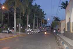
Square in the city center. | |||
| |||
 | |||
| Coordinates: 22°13′37″S 47°57′10″W / 22.22694°S 47.95278°W | |||
| Country |
| ||
| Region | Southeast | ||
| State |
| ||
| Founded | December 12, 1878 | ||
| Government | |||
| • Mayor | Ramiro de Campos (PSDB) | ||
| Area | |||
| • Municipality | 190.189 km2 (73.432 sq mi) | ||
| Elevation | 590 m (1,940 ft) | ||
| Population (2010) | |||
| • Municipality | 15,540 | ||
| • Density | 82/km2 (210/sq mi) | ||
| • Urban | 10,492 | ||
| Time zone | UTC-3 | ||
| Area code(s) | +55 | ||
| HDI (2000) | 0.767 – medium | ||
| Website | Official website | ||
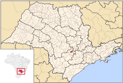
Cesário Lange is a Brazilian municipality in the state of São Paulo, located in the metropolitan area of Sorocaba, in mesoregion of Itapetininga and Microregion Tatuí.[1] Its estimated population in 2010 was 15,540 inhabitants. It has an area of 190.189 km².
History
- Founded in December 12, 1878 by João Mendes de Almeida, (Law No. 29/64).
- Its town category: Law No. 5285 of February 18, 1959, implementation January 1, 1960 (55 years).
- Political emancipation: Law No. 28 of August 19, 1966 (48 years)
- Origin of the name: Cesario Lange Adrien - first teacher
- Patron saint of the city: Santa Cruz
Highways
- SP-280: Rodovia Presidente Castelo Branco.
- SP-143: Cesário Lange / Pereiras - Rodovia Marechal Rondon.
- SP-141: Cesário Lange / Porangaba.
- SP-127: Cesário Lange / Tatuí.
- Highway Otávio Pilon: Vicinal Cesário Lange / Cerquilho - Rodovia do Açúcar.
Economy and religion
Agriculture, industry, religious tourism and leisure are some of the economic activities practiced in the city, which is a breeding center thoroughbred horses.
In the city of Cesário Lange, is the Associação Torre de Vigia de Bíblias e Tratados (Watch Tower Bible and Tract Association), the Brazilian headquarters of Jehovah's Witnesses religious group. That site is organized the work of the Witnesses in the country and print millions of Bible literature that are sent to all the Portuguese-speaking world, including Portugal.
References
- ↑ http://mapas.ibge.gov.br/divisao/viewer.htm (Portuguese). Retrivied 2015-01-27.
| ||||||||||||||||||||||||||||||||||||||||||||||||||||||||||||||||