Cerro Catedral
| Cerro Catedral | |
|---|---|
 | |
| Elevation | 2,405 m (7,890 ft) |
| Location | |
 Cerro Catedral Argentina | |
| Location | Río Negro, Patagonia, Argentina |
| Range | Andes |
| Coordinates | 41°11′S 71°27′W / 41.183°S 71.450°WCoordinates: 41°11′S 71°27′W / 41.183°S 71.450°W |
| Climbing | |
| Easiest route | South |
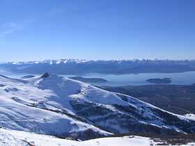
Cerro Catedral is a mountain located 19 kilometres (12 mi) from San Carlos de Bariloche, and inside the Nahuel Huapí National Park, Patagonia, Argentina.
The mountain holds one of the biggest ski centers in South America, with a skiable area of 2 km2 (0.77 sq mi), over 100 km (62 mi) of ski runs, and a lift capacity of 22,200 skiers per hour.[1] It is also very popular due to the magnificent view of the Nahuel Huapi lake. There are also a number of hotels and hostels at the foot of the mountain, and a summer hikers' hut called Refugio Lynch on one of the tops of the mountain.
During the summer, the Refugio Frey and a camping accommodate trekkers and rock climbers next to Tonček lagoon, near the Torre Principal; Catedral's highest point.
On August 27, 2005, the 1st South American Ski Mountaineering Championship in combination with the last race of the 2005 South American Ski Mountaineering Cup and the 2nd International Open of ski mountaineering was carried out on the Cerro Catedral.[2]
Climate
The climate is affected by the altitude. At higher elevations, at the weather station, the climate is classified as an alpine climate or a tundra climate (Köppen ET) while at lower elevations, the climate is classified as a cool mediterranean climate (Köppen: Csb).
| Climate data for Cerro Catedral | |||||||||||||
|---|---|---|---|---|---|---|---|---|---|---|---|---|---|
| Month | Jan | Feb | Mar | Apr | May | Jun | Jul | Aug | Sep | Oct | Nov | Dec | Year |
| Record high °C (°F) | 27.5 (81.5) |
25.5 (77.9) |
23.0 (73.4) |
19.4 (66.9) |
16.4 (61.5) |
13.4 (56.1) |
13.6 (56.5) |
12.3 (54.1) |
15.9 (60.6) |
21.2 (70.2) |
24.8 (76.6) |
25.6 (78.1) |
27.5 (81.5) |
| Average high °C (°F) | 12.8 (55) |
11.9 (53.4) |
10.6 (51.1) |
6.9 (44.4) |
3.7 (38.7) |
−0.2 (31.6) |
−0.5 (31.1) |
−0.6 (30.9) |
0.6 (33.1) |
5.2 (41.4) |
8.5 (47.3) |
11.0 (51.8) |
5.8 (42.4) |
| Daily mean °C (°F) | 7.5 (45.5) |
7.2 (45) |
5.7 (42.3) |
3.0 (37.4) |
0.8 (33.4) |
−2.4 (27.7) |
−2.7 (27.1) |
−2.9 (26.8) |
−2.3 (27.9) |
1.0 (33.8) |
3.7 (38.7) |
6.0 (42.8) |
2.1 (35.8) |
| Average low °C (°F) | 3.2 (37.8) |
3.0 (37.4) |
1.9 (35.4) |
−0.1 (31.8) |
−1.8 (28.8) |
−4.6 (23.7) |
−5 (23) |
−5.1 (22.8) |
−4.7 (23.5) |
−1.8 (28.8) |
0.2 (32.4) |
2.0 (35.6) |
−1.1 (30) |
| Record low °C (°F) | −6.8 (19.8) |
−7.0 (19.4) |
−7.6 (18.3) |
−10.7 (12.7) |
−11.7 (10.9) |
−14.0 (6.8) |
−13.9 (7) |
−12.9 (8.8) |
−12.4 (9.7) |
−10.2 (13.6) |
−8.6 (16.5) |
−7.6 (18.3) |
−14.0 (6.8) |
| Average precipitation mm (inches) | 59 (2.32) |
53 (2.09) |
54 (2.13) |
100 (3.94) |
196 (7.72) |
206 (8.11) |
222 (8.74) |
264 (10.39) |
104 (4.09) |
79 (3.11) |
52 (2.05) |
78 (3.07) |
1,467 (57.76) |
| Avg. precipitation days | 7 | 8 | 8 | 10 | 16 | 15 | 15 | 16 | 9 | 7 | 8 | 7 | 126 |
| Average relative humidity (%) | 67.5 | 65.0 | 69.0 | 77.5 | 80.0 | 85.0 | 83.5 | 84.5 | 80.5 | 75.5 | 69.5 | 70.0 | 75.6 |
| Mean monthly sunshine hours | 294.5 | 254.3 | 229.4 | 171.0 | 130.2 | 90.0 | 86.8 | 102.3 | 156.0 | 217.0 | 237.0 | 291.4 | 2,259.9 |
| Percent possible sunshine | 65 | 65 | 59 | 52 | 41 | 32 | 28 | 32 | 43 | 53 | 55 | 62 | 49 |
| Source #1: Servico Meteorológico National[3] | |||||||||||||
| Source #2: Secretaria de Mineria (extremes and sun, 1961–1970 and 1981–1990)[4] | |||||||||||||
Gallery
-

Cerro Catedral in winter
-

Ski lift and Refugio Lynch on the top of the Cerro Catedral
-
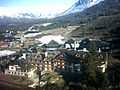
Ski resort during the summer
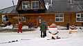
-

Cerro Catedral Ski resort
-
Cerro Catedral Ski resort Refugio Lynch
Panoramas


References
- ↑ "Argentina’s Catedral ski resort becoming a winter sport giant". Ski Rebel Magazine. Retrieved 2009-08-10.
- ↑ Declaración N° 1126-CM-05 (Spanish), Municipal Council of Bariloche, August 9, 2005.
- ↑ Datos Estadísticos (Período 1961-1970), Servico Meteorológico National, Accessed 23 August 2012
- ↑ "Provincia de Rio Negro - Clima Y Meteorologia: Datos Meteorologicos Y Pluviometicos" (in Spanish). Secretaria de Mineria de la Nacion (Argentina). Retrieved December 17, 2013.
External links
- Catedral Alta Patagonia
- Image of Catedral mountain in winter (1000x644 pixels)
- Panoramic view of higher ski areas in winter (2400x626 pixels)
- Panoramic view from cerro the Catedral sky resort to the Andes in winter (2600x846 pixels)
- Pataclimb.com, an online climbing guidebook to Cerro Catedral