Cerro Cabrillo
| Cerro Cabrillo | |
|---|---|
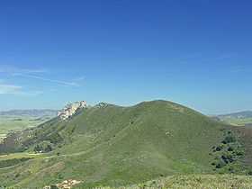 A picture of Cerro Cabrillo from Black Hill. A portion of Hollister Peak can be seen. | |
| Elevation | 914 ft (279 m) NAVD 88[1] |
| Location | |
| Location | San Luis Obispo County, California |
| Range | Santa Lucia Range |
| Coordinates | 35°21′08″N 120°48′54″W / 35.352122356°N 120.815056678°WCoordinates: 35°21′08″N 120°48′54″W / 35.352122356°N 120.815056678°W[2] |
| Topo map | USGS Morro Bay South |
| Geology | |
| Type | Volcanic plug |
| Age of rock | 20 million years |
Cerro Cabrillo, also known locally as Cabrillo Peak, is a rocky mountain in eastern Morro Bay State Park, San Luis Obispo County, central California.
Geography
Cerro Cabrillo is one of the Nine Sisters, a group of nine volcanic landmarks in the area. Others include Morro Rock and Hollister Peak. It is named after Juan Rodríguez Cabrillo, a Spanish maritime explorer, who was sailing off the coast in 1542.
%2C_Morro_Bay%2C_CA.jpg)
The rock outcrop, composed mostly of rhyodacite, is a volcanic plug formed when magma welled up underneath a layer of softer rock and solidified. The softer overlying rock has since eroded away leaving the distinct rugged shape.[3] On its east face is a rock formation named Tiki Rock, because of its resemblance to a Polynesian Tiki carving.
Access
The slopes and peak of Cerro Cabrillo are popular with hikers and rock climbers, with trailheads in Morro Bay State Park.
Its slopes support many chaparral and coastal sage scrub wild flowers, such as Deer Weed (Acmispon glaber), Soap plant (Chlorogalum pomeridianum), and Chaparral checkerbloom (Sidalcea hickmanii).
See also
References
- ↑ "Cerro Cabrillo, California". Peakbagger.com. Retrieved 2012-03-31.
- ↑ "Rocky Butte SE of Black Hill". NGS data sheet. U.S. National Geodetic Survey. Retrieved 2009-12-17.
- ↑ "The Nine Sisters of San Luis Obispo County". Santa Lucia Chapter, Sierra Club. Retrieved 2009-07-01.
External links
- "Cerro Cabrillo". Geographic Names Information System. United States Geological Survey.
- Hikespeak.com: "Cerro Cabrillo and Tiki Rock in Morro Bay State Park" — with photos.