Central Italy
For the EU constituency, see Central Italy (European Parliament constituency).
 | |
| Regional statistics | |
|---|---|
| Composition | |
| Area - Total |
58,051 km2 (22,414 sq mi) |
| Population - Total - Density |
11,945,000[1] (2010 est.) 205.7/km² (532.9/sq mi) |
| Largest city | Rome (pop. 2,758,991) |
| GDP | €343.7 billion (2008)[2] |
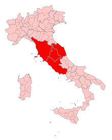
Central Italy (Italian: Italia centrale or just Centro) is one of the five official statistical regions of Italy used by the National Institute of Statistics (ISTAT), a first level NUTS region and a European Parliament constituency.
Regions
Central Italy encompasses four of the country's 20 regions:
As geographical region, Central Italy also includes the regions of Abruzzo and Molise.[3][4][5]
See also
- National Institute of Statistics (Italy)
- Italian NUTS level 1 regions:
- Northern Italy
- Southern Italy
References
- ↑ Source: Istat 2010
- ↑ Source: Eurostat
- ↑ Source: Touring Club Italiano (TCI), "Atlante stradale d'Italia". 1999-2000 TCI Atlas. ISBN 88-365-1115-5 (Northern Italy volume) – ISBN 88-365-1116-3 (Central Italy volume) – ISBN 88-365-1117-1 (Southern Italy volume)
- ↑ Source: De Agostini, "Atlante Geografico Metodico". ISBN 88-415-6753-8
- ↑ Source: Enciclopedia Italiana "Treccani"
| ||||||||||||||||||||||||||||||||||||||||||||