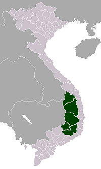
Central Highlands (Vietnam)

Tây Nguyên, translated as Western Highlands and sometimes also called Central Highlands, is one of the regions of Vietnam. It contains the provinces of Đắk Lắk, Đắk Nông, Gia Lai, Kon Tum, Lâm Đồng.
This region is sometimes referred to as Cao nguyên Trung bộ (literally "Midland Highlands"), and was referred to during the Republic of Vietnam as Cao nguyên Trung phần (literally "Central Highlands").
Provinces
| Provinces | Capital | Population (Census April 1, 2009) | Area (km²) |
|---|---|---|---|
| Đắk Lắk | Buôn Ma Thuột | 1,737,600 | 13,139.2 km² |
| Đắk Nông | Gia Nghĩa | 407,300 | 6,516.9 km² |
| Gia Lai | Pleiku | 1,161,700 | 15,536.9 km² |
| Kon Tum | Kon Tum | 383,100 | 9,690.5 km² |
| Lâm Đồng | Da Lat | 1,179,200 | 9,776.1 km² |
Demographics
The Tây Nguyên region is home to a large population of ethnic minorities such as the people of Malayo-Polynesian languages (Jarai and Ede) and the people of Mon-Khmer languages (Bahnar and K'hor). They have made up the majority of the region's population for a long time. However, this changed over the last few decades due to immigration of Kinh people (ethnic Vietnamese). As of 2006, there was a Kinh majority in the Central Highlands, while there were still several districts that had a non-Kinh majority (most of them in Gia Lai Province).[1]
The Central Highlands had a population of 4,935,200 people in 2007.[2] As a result of resettlement campaigns of various governments (colonial, South Vietnam, post-war), the region's population has increased significantly. It was 420,000 in 1926, but had reached 2.8 million in 1991[3]:200 and 4.2 million in 2000.[4] Population growth between 2000 and 2007 averaged 2.24% per year, which is significantly higher than that of other regions, such as the South Central Coast (1.22%) and North Central Coast (0.86%).[2] Growth has been particularly fast in Đắk Nông Province with 4.76%, followed by Kon Tum Province with 2.64%.[2]
The Central Highlands' population density is 72.2/km² as of 2007, higher than that of the South Central Coast (68.4), but lower than that of the North Central Coast (86.1).[2] The most densely populated provinces are Đắk Lắk and Lâm Đồng, while Kon Tum is the least densely populated.
Geography

Tây Nguyên is a plateau، bordering the lower part of Laos and northeastern Cambodia. Kon Tum Province shares a border with both Laos and Cambodia but Gia Lai Province and Đắk Lắk Province only share borders with Cambodia. Lâm Đồng Province is landlocked, and thus has no international border.
Actually, Tây Nguyên is not situated on a unique plateau, instead it lies on series of contiguous plateaus, namely Kon Tum Plateau at the height of 500 m, Kon Plông Plateau, Kon Hà Nừng Plateau, Pleiku Plateau with the height of around 800m, Mdrak Plateau of approximately 500 m, Đắk Lắk Plateau of around 800m, Mơ Nông Plateau with the height of about 800–1000 m, Lâm Viên Plateau of approximately 1500 m and Di Linh Plateau of about 900–1000 m. All of these plateau are surrounded by the high mountain ranges and mounts (South Annamite Range).
Tây Nguyên can be divided into 3 subregions according to its deviation in topography and climate, namely: North Tây Nguyên (Bắc Tây Nguyên) (inclusive of Kon Tum and Gia Lai provinces), Middle Tây Nguyên (Trung Tây Nguyên) (covering provinces of Đắk Lắk and Đắk Nông), South Tây Nguyên (Nam Tây Nguyên) (Lâm Đồng). Trung Tây Nguyên has lower altitude and therefore has a higher temperature from other two subregions.
Agriculture
Tây Nguyên contains in it many primitive forests and is protected in its national parks, such as Cát Tiên National Park, Yok Đôn National Park, Kon Ka Kinh National Park. The region has an average altitude of 500–600 m with basalt soil, suitable for planting coffee tree, cacao, pepper, and white mulberry. Cashew and rubber plants are also planted here. Coffee is the most important product of Tây Nguyên, with production centred in Đắk Lắk Province. The provincial capital of Buôn Ma Thuột hosts a number of major coffee factories, including ones owned by major producer Trung Nguyên. Tây Nguyên is also the third natural bauxite source in the world. Plans for bauxite mining in the area have met with some controversy, both because of the environmental impact of the proposed operations, and because of labour issues.
Flora and fauna
Tây Nguyên is home to the most prominent and also the most endangered species in Vietnam and Southeast Asia, namely, the Indochinese tiger, the huge gaur, the Wild Asian Water Buffalo, the banteng, and the Asian elephant.
| Wikimedia Commons has media related to Tay Nguyen (Central Highlands). |
References
- ↑ General Statistics Office (1996): Population Data of Sparsely Populated Areas in Vietnam. Statistical Publishing House, Hanoi
- ↑ 2.0 2.1 2.2 2.3 calculations based on General Statistics Office (2009): Socio-economical Statistical Data of 63 Provinces and Cities. Statistical Publishing House, Hanoi
- ↑ McElwee, Pamela 2008: Becoming Socialist or Becoming Kinh? Government Policies for Ethnic Minorities in the Socialist Republic of Vietnam. in Duncan, Christopher (ed.): Civilizing the Margins - Southeast Asian Government Policies for the Development of Minorities. NUS Press, Singapore
- ↑ General Statistics Office (2009): Socio-economic Statistical Data of 63 Provinces and Cities, Vietnam. Statistical Publishing House, Hanoi
Coordinates: 13°45′N 108°15′E / 13.750°N 108.250°E