Central High School Neighborhood Historic District
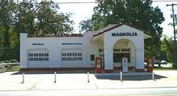
The Central High School Neighborhood Historic District comprises the area in Little Rock, Arkansas surrounding Little Rock Central High School. The area was designated to provide historic context to the National Historic Landmark school. It includes the restored Magnolia Gas Station, which was a staging area for the media during the school integration crisis of 1957, and which, until recently, served as the National Park Service visitor center.[2] Residences in the surrounding area include bungalows, Tudor Revival and Colonial Revival styles.
References
|
|---|
| | Topics | |
|---|
| | Lists by states | |
|---|
| | Lists by insular areas | |
|---|
| | Lists by associated states | |
|---|
| | Other areas | |
|---|
|
-
 Category Category
-
 Portal Portal
-
 WikiProject WikiProject
|
|