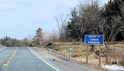
Central Frontenac
| Central Frontenac | |
|---|---|
| Township (lower-tier) | |
| Township of Central Frontenac | |
|
Road sign along Highway 7 | |
 Central Frontenac | |
| Coordinates: 44°43′N 76°48′W / 44.717°N 76.800°WCoordinates: 44°43′N 76°48′W / 44.717°N 76.800°W | |
| Country |
|
| Province |
|
| County | Frontenac |
| Incorporated | 1998 |
| Government | |
| • Type | Township |
| • Mayor | Frances Smith |
| • Federal riding | Lanark—Frontenac—Lennox and Addington |
| • Prov. riding | Lanark—Frontenac—Lennox and Addington |
| Area[1] | |
| • Land | 1,025.17 km2 (395.82 sq mi) |
| Population (2011)[1] | |
| • Total | 4,556 |
| • Density | 4.4/km2 (11/sq mi) |
| Time zone | EST (UTC-5) |
| • Summer (DST) | EDT (UTC-4) |
| Postal Code | K0H |
| Area code(s) | 613 |
| Website | www.centralfrontenac.com |
Central Frontenac is a township in eastern Ontario, Canada in the County of Frontenac.
Central Frontenac was created in 1998 through an amalgamation of the Townships of Hinchinbrooke, Kennebec, Olden and Oso.
Communities
- Arden, web site http://www.ardenvillageontario.com/
- Ardendale
- Bordenwood
- Burke Settlement
- Camp Oconto 44°41′10″N 76°40′23″W / 44.686°N 76.673°W
- Clarendon Station 44°52′26″N 76°41′46″W / 44.874°N 76.696°W
- Cole Lake
- Crow Lake
- Echo
- Elm Tree
- Godfrey
- Henderson
- Kirk Cove 44°47′35″N 76°59′02″W / 44.793°N 76.984°W
- Long Lake 44°41′24″N 76°45′47″W / 44.690°N 76.763°W
- McLean 44°39′14″N 76°50′02″W / 44.654°N 76.834°W
- Mountain Grove 44°44′02″N 76°50′38″W / 44.734°N 76.844°W
- Oak Flats 44°32′53″N 76°44′28″W / 44.548°N 76.741°W
- Oconto 44°43′16″N 76°40′30″W / 44.721°N 76.675°W
- Oso 44°49′08″N 76°41′02″W / 44.819°N 76.684°W
- Parham
- Piccadilly 44°43′59″N 76°56′53″W / 44.733°N 76.948°W
- Ronaldson 44°40′59″N 77°01′59″W / 44.683°N 77.033°W
- Seouls Corners 44°46′55″N 76°48′00″W / 44.782°N 76.800°W
- Sharbot Lake
- Tichborne
- Wagarville 44°38′24″N 76°48′11″W / 44.640°N 76.803°W
- Wilkinson 44°31′59″N 76°48′43″W / 44.533°N 76.812°W
- Zealand 44°50′02″N 76°37′12″W / 44.834°N 76.620°W
Demographics
| |||||||||||||||||||
According to the 2006 Statistics Canada Census:[5]
- Private dwellings occupied by usual residents: 1852 (total dwellings: 3243)
- Mother tongue:
- English as first language: 93.1%
- French as first language: 1.2%
- English and French as first language: 0.2%
- Other as first language: 5.5%
Population trend:[6]
- Population in 2011: 4556
- Population in 2006: 4665
- Population in 2001: 4557
- Population in 1996:
- Hinchinbrooke (township): 1328
- Kennebec (township): 968
- Olden (township): 906
- Oso (township): 1413
- Population in 1991:
- Hinchinbrooke (township): 1117
- Kennebec (township): 765
- Olden (township): 811
- Oso (township): 1361
Transportation
The main road is Highway 7 which runs through the entire township from east to west. County Road 38 intersects Highway 7 at Sharbot Lake and runs south to Kingston.
The route of the former Kingston and Pembroke Railway runs through the township, and has been converted into the K&P Rail Trail.
See also
References
- ↑ 1.0 1.1 "Central Frontenac census profile". 2011 Census of Population. Statistics Canada. Retrieved 2012-02-13.
- ↑ "2011 Community Profiles". Canada 2011 Census. Statistics Canada. July 5, 2013. Retrieved 2012-02-13.
- ↑ "2006 Community Profiles". Canada 2006 Census. Statistics Canada. March 30, 2011. Retrieved 2012-02-13.
- ↑ "2001 Community Profiles". Canada 2001 Census. Statistics Canada. February 17, 2012. Retrieved 2012-02-13.
- ↑ Statistics Canada 2006 Census - Central Frontenac community profile
- ↑ Statistics Canada: 1996, 2001, 2006 census
 |
North Frontenac | Lanark Highlands |  | |
| Addington Highlands | |
Tay Valley | ||
| ||||
| | ||||
| Stone Mills | South Frontenac |
