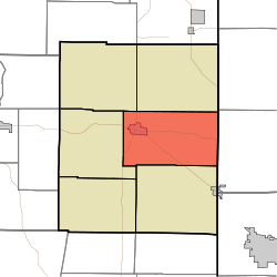
Center Township, Union County, Indiana
| Center Township | |
|---|---|
| Township | |
 Location in Union County | |
| Coordinates: 39°37′40″N 84°53′01″W / 39.62778°N 84.88361°WCoordinates: 39°37′40″N 84°53′01″W / 39.62778°N 84.88361°W | |
| Country | United States |
| State | Indiana |
| County | Union |
| Government | |
| • Type | Indiana township |
| Area | |
| • Total | 28 sq mi (70 km2) |
| • Land | 27.92 sq mi (72.3 km2) |
| • Water | 0.08 sq mi (0.2 km2) 0.29% |
| Elevation | 1,050 ft (320 m) |
| Population (2010) | |
| • Total | 3,048 |
| • Density | 109.1/sq mi (42.1/km2) |
| ZIP code | 47353 |
| GNIS feature ID | 0453194 |
Center Township is one of six townships in Union County, Indiana, United States. As of the 2010 census, its population was 3,048 and it contained 1,330 housing units.[1]
Geography
According to the 2010 census, the township has a total area of 28 square miles (73 km2), of which 27.92 square miles (72.3 km2) (or 99.71%) is land and 0.08 square miles (0.21 km2) (or 0.29%) is water.[1]
Cities, towns, villages
- Liberty (the county seat)
Cemeteries
The township contains these five cemeteries: Calvary, Drook, Pentecost, Sering and West Point.
Airports and landing strips
- E-Z Acres Airport
Landmarks
- Whitewater Memorial State Park (east edge)
School districts
- Union County-College Corner Joint School District
Political districts
- Indiana's 6th congressional district
- State House District 55
- State Senate District 43
References
- United States Census Bureau 2007 TIGER/Line Shapefiles
- United States Board on Geographic Names (GNIS)
- IndianaMap
- ↑ 1.0 1.1 "Population, Housing Units, Area, and Density: 2010 - County -- County Subdivision and Place -- 2010 Census Summary File 1". United States Census. Retrieved 2013-05-10.
External links
 |
Brownsville Township | Harrison Township |  | |
| Liberty Township | |
Israel Township, Preble County, Ohio | ||
| ||||
| | ||||
| Union Township |
| |||||||||||||||||||||