Cefn-coed-y-cymmer
Cefn-coed-y-cymmer (also Cefn Coed-y-cymmer) (Welsh: Cefncoedycymer) is a small community on the northwestern edge of Merthyr Tydfil County Borough in south Wales. It is situated in the neck of land between the rivers Taf Fawr and Taf Fechan at their confluence (Welsh: 'cymer'). The village lies within the community of Vaynor. Immediately to the north of the village is the hill of Cefn Cil Sanws on the southern slopes of which is Merthyr Tydfil Golf Club. The village is bounded both to the north and the west by the Brecon Beacons National Park.[1]
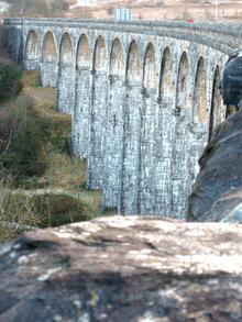
Notable features of the village are the A465 Heads of the Valleys Road and the impressive curving Cefn Coed Viaduct (51°45′33″N 3°24′23″W / 51.7593°N 3.4064°W), an 1866 Grade II* listed building which formerly carried the Brecon and Merthyr railway over the River Taff but which now carries the Taff Trail, route 8 of the National Cycleway. It is the third largest viaduct in Wales and was designed by engineers Alexander Sutherland and Henry Conybeare. Sutherland was a friend of Robert Thompson Crawshay of the nearby Cyfarthfa Ironworks, and the viaduct was built on a curve to satisfy conditions laid down by the Crawshay Estate.[2]
Beyond the last buildings of Cefn, and parallel to the A470 road, lies the Jewish cemetery. It was established by the then-Merthyr Hebrew Congregation and consecrated in the 1860s, one of very few north of Cardiff. It is located on a steep slope with a stone wall and a small chapel (ohel)
References
| Wikimedia Commons has media related to Cefn Coed Viaduct. |
- ↑ Ordnance Survey 1:25,000 scale Explorer map sheet OL12 Brecon Beacons National Park: western area
- ↑ Merthyr Tydfil Heritage Regeneration Trust. Heritage Plaques (Places): Cefn Coed or Pontycapel Viaduct