Cedarville, Maryland
| Cedarville, Maryland | |
|---|---|
| Census-designated place | |
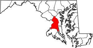
 Cedarville, Maryland Location within the state of Maryland | |
| Coordinates: 38°39′46″N 76°48′07″W / 38.66278°N 76.80194°WCoordinates: 38°39′46″N 76°48′07″W / 38.66278°N 76.80194°W | |
| Country |
|
| State |
|
| County |
|
| Area | |
| • Total | 9.0 sq mi (23.3 km2) |
| • Land | 9.0 sq mi (23.3 km2) |
| • Water | 0 sq mi (0 km2) |
| Elevation | 266 ft (81 m) |
| Population (2010) | |
| • Total | 1,394 |
| • Density | 150/sq mi (60/km2) |
| Time zone | Eastern (EST) (UTC-5) |
| • Summer (DST) | EDT (UTC-4) |
| Area code(s) | 301 |
| GNIS feature ID | 597207 |
Cedarville is an unincorporated community and census-designated place in southern Prince George's County, Maryland in the United States of America.[1] As of the 2010 census the population was 1,394.[2]
Geography
According to the U.S. Census Bureau, Cedarville had an area of 9.0 square miles (23.3 km2), all of it land.[3] The CDP is bordered to the northwest by Brandywine, to the north by Croom CDP, to the east by Baden, and to the south by Charles County.
References
- ↑ U.S. Geological Survey Geographic Names Information System: Cedarville, Maryland
- ↑ "Profile of General Population and Housing Characteristics: 2010 Demographic Profile Data (DP-1): Cedarville CDP, Maryland". U.S. Census Bureau, American Factfinder. Retrieved December 16, 2011.
- ↑ "Geographic Identifiers: 2010 Demographic Profile Data (G001): Cedarville CDP, Maryland". U.S. Census Bureau, American Factfinder. Retrieved December 16, 2011.