Cedar Township, Chase County, Kansas
| Cedar Township | |
|---|---|
| Township | |
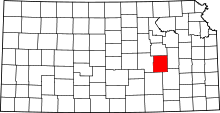
 Location in Chase County | |
| Coordinates: 38°09′30″N 096°47′41″W / 38.15833°N 96.79472°WCoordinates: 38°09′30″N 096°47′41″W / 38.15833°N 96.79472°W | |
| Country | United States |
| State | Kansas |
| County | Chase |
| Area | |
| • Total | 54.96 sq mi (142.35 km2) |
| • Land | 54.84 sq mi (142.04 km2) |
| • Water | 0.12 sq mi (0.32 km2) 0.22% |
| Elevation | 1,319 ft (402 m) |
| Population (2000) | |
| • Total | 116 |
| • Density | 2.1/sq mi (0.8/km2) |
| GNIS feature ID | 0477800 |
Cedar Township is a township in Chase County, Kansas, USA. As of the 2000 census, its population was 116.
Geography
Cedar Township covers an area of 54.96 square miles (142.3 km2) and contains no incorporated settlements. According to the USGS, it contains two cemeteries: Griffith and Wonsevu.
The streams of Bills Creek, Brush Creek, Middle Creek and Turkey Creek run through this township.
Transportation
Cedar Township contains one airport or landing strip, Clothier Landing Field.
Further reading
See also: List of books about Chase County, Kansas
References
External links
- City-Data.com
- Chase County Maps: Current, 1936
| |||||||||||||||||||||||||||||