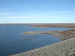
Cedar Bluff Reservoir
| Cedar Bluff Reservoir | |
|---|---|
 | |
| Location | Trego County, Kansas |
| Coordinates | 38°47′30″N 99°52′41″W / 38.79167°N 99.87806°WCoordinates: 38°47′30″N 99°52′41″W / 38.79167°N 99.87806°W |
| Type | Reservoir |
| Primary inflows | Smoky Hill River |
| Primary outflows | Smoky Hill River |
| Basin countries | United States |
| Managing agency | U.S. Bureau of Reclamation |
| Built | April 1, 1949 |
| First flooded | September 29, 1951 |
| Surface area | 6,869 acres (27.80 km2) |
| Max. depth | 55 ft (17 m) |
| Water volume |
Current: 79,252 acre·ft (0.097756 km3) Maximum: 445,090 acre·ft (0.54901 km3) |
| Shore length1 | 50 mi (80 km) |
| Surface elevation | 2,144 ft (653 m) |
| 1 Shore length is not a well-defined measure. | |
Cedar Bluff Reservoir is a reservoir in Trego County, Kansas, United States.
The reservoir was created by the 1949 Cedar Bluff Dam, a 1949 project of the United States Bureau of Reclamation. The multi-purpose project impounds the Smoky Hill River for recreation, irrigation, flood control, and municipal water supply.[1] The lake is also the site of the Cedar Bluff State Park.
Diminishing water levels halted delivery of irrigation water in 1978, and the dissolution of the Cedar Bluff Irrigation District in 1994.[2]
References
- ↑ Simonds, William Joe (1998). "Cedar Bluff Unit - Project Details". Research on Historic Reclamation Projects. United States Bureau of Reclamation. Retrieved 2012-04-21.
- ↑ http://www.usbr.gov/projects/Project.jsp?proj_Name=Cedar+Bluff+Unit