Cavendish (CDP), Vermont
| Cavendish, Vermont | |
|---|---|
| Census-designated place | |
 Cavendish, Vermont | |
| Coordinates: 43°22′55″N 72°36′29″W / 43.38194°N 72.60806°WCoordinates: 43°22′55″N 72°36′29″W / 43.38194°N 72.60806°W | |
| Country | United States |
| State | Vermont |
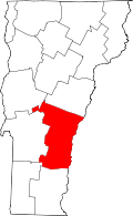
| County | Windsor |
| Area | |
| • Total | 0.7 sq mi (1.7 km2) |
| • Land | 0.7 sq mi (1.7 km2) |
| • Water | 0.0 sq mi (0.0 km2) |
| Elevation | 890 ft (270 m) |
| Population (2010) | |
| • Total | 179 |
| • Density | 270/sq mi (110/km2) |
| Time zone | Eastern (EST) (UTC-5) |
| • Summer (DST) | EDT (UTC-4) |
| ZIP code | 05142 |
| Area code(s) | 802 |
| FIPS code | 50-12175[1] |
| GNIS feature ID | 1456794[2] |
Cavendish is a census-designated place (CDP) that comprises the central village of the town of Cavendish, Windsor County, Vermont, United States. As of the 2010 census, the population of the CDP was 179,[3] compared to 1,367 for the entire town of Cavendish.
Geography
Cavendish is located along Vermont Route 131 in the Black River valley. Route 131 heads west to Proctorsville, a larger village within the town of Cavendish, then connects with Vermont Route 103 to Ludlow. To the east, Route 131 leads to the village of Ascutney on the Connecticut River.
References
- ↑ "American FactFinder". United States Census Bureau. Retrieved 2008-01-31.
- ↑ "US Board on Geographic Names". United States Geological Survey. 2007-10-25. Retrieved 2008-01-31.
- ↑ "Profile of General Population and Housing Characteristics: 2010 Demographic Profile Data (DP-1): Cavendish CDP, Vermont". U.S. Census Bureau, American Factfinder. Retrieved August 1, 2012.
| |||||||||||||||||||||||||