Cave of Swallows
| Cave of Swallows | |
|---|---|
|
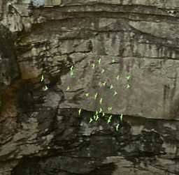
A flock of conures in the Sótano de las Golondrinas | |
| Location |
Aquismón, San Luis Potosí, |
| Length | VR = 512m. Entrance pit: L = 135m, W = 305m, H = 333-376m. Ar = 33,110m2 |
| Discovery | December 27, 1966[1] |
| Hazards | Free fall |
| Access | Easy. No restrictions |
The Cave of Swallows , also called Cave of the Swallows (Spanish: Sótano de las Golondrinas), is an open air pit cave in the Municipality of Aquismón, San Luis Potosí, Mexico. The elliptical mouth, on a slope of karst, is 49 by 62 m wide[2] and is undercut around all its perimeter, further widening to a room approximately 303 by 135 meters (994 by 442 ft) wide.[2] The floor of the cave is a 333 meter (1092 ft) freefall drop from the lowest side of the opening, with a 370 meter (1,214 ft) drop from the highest side,[2] making it the largest known cave shaft in the world, the second deepest pit in Mexico and perhaps the 11th deepest in the world.[3] A skyscraper such as New York City's Chrysler Building could easily fit wholly within it.
History
Opened up by water erosion in a fault on an impermeable limestone plain and with a roughly conical shape, the cave has been known to the local Huastec people since ancient times. The first documented exploration was on 27 December 1966 by T. R. Evans, Charles Borland and Randy Sterns.[2]
Etymology

The cave's Spanish name Sótano de las Golondrinas means Basement of the Swallows owing to the many birds which live in holes on the cave walls.[4] These are mostly white-collared swifts (vencejos in Spanish) and green parakeets (periquillo quila).
Each morning, flocks of birds exit the cave by flying in circles, gaining height until they reach the opening and the sky. In the evenings a large flock of swifts circle the mouth of the cave and about once each minute, a group of perhaps fifty breaks off and heads straight down towards the opening. When they cross the edge, the birds pull in their wings and free-fall, extending their wings and pulling out of the dive when they reach the heights of their nests. Watching this has become popular with tourists.
Description
Temperatures in the cave are low. Vegetation grows thickly at the mouth,[5] where rains can cause waterfalls cascading into the cave.[5] The cave floor is covered with a thick layer of debris and guano on which "millipedes, insects, snakes, and scorpions" live.[4] There is also a narrow sinkhole in a fault of lower Cretaceous limestone which goes down at least a further 512 m.[6]
Extreme sports tourism

The cave is a popular vertical caving destination. The high side of the mouth is covered with heavy foliage, so cavers most often fix their ropes on the low side, where bolts have been fixed into the rock and the area is clear of obstructions.[4] Rappelling to the floor takes about twenty minutes. Climbing back out may take from forty minutes to more than two hours. A person without a parachute would take almost ten seconds to freefall from the mouth to the floor, hence the pit is also popular with extreme sports enthusiasts for BASE jumping.[7][8] An average-sized hot air balloon has been navigated through the 160-foot (49 m) wide opening and landed on the floor below.[9] Base jumpers can get out in about 10 minutes using an extraction rope. (video: Journey to the Earth's Core-History Channel).
See also
- Cenote, the term for similar caves found in the Yucatan Peninsula of Mexico
- List of caves
Notes and references
- ↑ Date of first documented exploration, the cave has been known locally for at least many centuries
- ↑ 2.0 2.1 2.2 2.3 Russell, William H.; Terry W. Raines (1967). Caves of the Inter-American Highway. Association of Mexican Cave Studies.
- ↑ Hunker, Louisa. "Pits in Potosi". The Leader. National Outdoor Leadership School. Retrieved 2007-04-12.
- ↑ 4.0 4.1 4.2 "www.showcaves.com". Retrieved 2007-04-08.
- ↑ 5.0 5.1 "redescolar.ilce.edu.mx" (in Spanish). Retrieved 8 April 2007.
- ↑ "Sótano de las Golondrinas – Cave of the Swallows by Wondermondo". Retrieved 9 July 2010.
- ↑ "Troy Hartman.com". Retrieved 8 April 2007.
- ↑ "Base Jumpers". Retrieved 8 April 2007.
- ↑ "www.lumika.org". Retrieved 8 April 2007.
Coordinates: 21°35′59″N 99°05′56″W / 21.59972°N 99.09889°W