Caudiès-de-Conflent
| Caudiès-de-Conflent | |
|---|---|
|
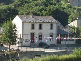
The old school and village hall | |
 Caudiès-de-Conflent | |
|
Location within Languedoc-Roussillon region  Caudiès-de-Conflent | |
| Coordinates: 42°34′05″N 2°09′43″E / 42.5681°N 2.1619°ECoordinates: 42°34′05″N 2°09′43″E / 42.5681°N 2.1619°E | |
| Country | France |
| Region | Languedoc-Roussillon |
| Department | Pyrénées-Orientales |
| Arrondissement | Prades |
| Canton | Mont-Louis |
| Intercommunality | Capcir Haut-Conflent |
| Government | |
| • Mayor (2008–2014) | Robert Joulia |
| Area1 | 6.50 km2 (2.51 sq mi) |
| Population (1999)2 | 6 |
| • Density | 0.92/km2 (2.4/sq mi) |
| INSEE/Postal code | 66047 / 66220 |
| Elevation |
1,616–2,045 m (5,302–6,709 ft) (avg. 1,625 m or 5,331 ft) |
|
1 French Land Register data, which excludes lakes, ponds, glaciers > 1 km² (0.386 sq mi or 247 acres) and river estuaries. 2 Population without double counting: residents of multiple communes (e.g., students and military personnel) only counted once. | |
Caudiès-de-Conflent (Catalan: Caudiers de Conflent) is a commune in the Pyrénées-Orientales department in southern France.
Geography
Caudiès-de-Conflent is located in the canton of Mont-Louis and in the arrondissement of Prades.
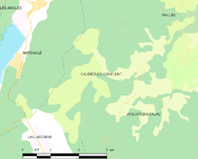
Map of Caudiès-de-Conflent and its surrounding communes
See also
References
| Wikimedia Commons has media related to Caudiès-de-Conflent. |