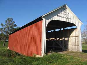
Catlin Covered Bridge
| Catlin Covered Bridge | |
| National Register of Historic Places | |
 | |
| Official name: Catlin Covered Bridge | |
| Named for: Catlin, Indiana | |
| Country | |
|---|---|
| State | |
| County | Parke |
| Township | Adams |
| Crosses | Bill Diddle Creek |
| Coordinates | 39°47′29.93″N 87°14′17.31″W / 39.7916472°N 87.2381417°WCoordinates: 39°47′29.93″N 87°14′17.31″W / 39.7916472°N 87.2381417°W |
| Length | 72 ft (22 m) 54ft +9ft overhangs on each end |
| Width | 16 ft (5 m) |
| Clearance | 13 ft (4 m) |
| Builder | McDaniel, Clark |
| Design | Single Burr Arch truss bridge |
| Material | Wood |
| Built | 1907 |
| WGCB Number | #14-61-15 [1] |
| Added to NRHP | Dec 22, 1978 |
| NRHP Ref# | 78000387 [2] |
| MPS | Parke County Covered Bridges TR |
|
Location of the Catlin Covered Bridge in Indiana
| |
 Location of Indiana in the United States
| |
The Catlin Covered Bridge is a single span Burr Arch truss covered bridge structure that was built by Clark McDaniel in 1907. Originally it was located on the Rockville Rosedale Road on the north side of Caitlin crossing Sunderland Creek. It was relocated to its present spot, at the Rockville Golf Course, in 1961 by Garrard Brothers Trucking where it crosses Bill Diddle Creek.[3]
Gallery
See also
- List of Registered Historic Places in Indiana
- Parke County Covered Bridges
- Parke County Covered Bridge Festival
References
- ↑ http://www.indianacrossings.org/bridgeLinks/14-61-15.html
- ↑ "National Register Information System". National Register of Historic Places. National Park Service. 2007-01-23.
- ↑ "Catlin Covered Bridge". Parke County Incorporated / Parke County Convention and Visitors Commission. Retrieved 2012-10-18.

