Cathedral Rock National Park
This article is about Cathedral Rock National Park. For other uses, see Cathedral Rock (disambiguation).
| Cathedral Rock National Park | |
|---|---|
|
IUCN category II (national park) | |
|
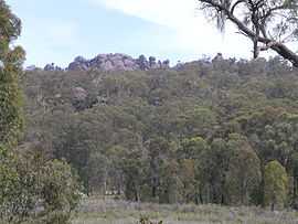
Granite tors in Cathedral Rock National Park | |
| Coordinates | 30°25′51″S 152°16′01″E / 30.43083°S 152.26694°ECoordinates: 30°25′51″S 152°16′01″E / 30.43083°S 152.26694°E |
| Established | 1978 |
| Area | 89 km2 (34.4 sq mi) |
| Managing authorities | NSW National Parks and Wildlife Service |
| Official site | http://www.nationalparks.nsw.gov.au |
Cathedral Rock is a national park eight kilometres west of Waterfall Way in New South Wales, Australia, 70 kilometres east of Armidale and about 555 kilometres north of Sydney.
This park is lying between the Guy Fawkes River and Macleay Range, and is about six kilometres west of Ebor, New South Wales.
The highest peak of the New England Tableland, Round Mountain, is located in the park.
See also

Gleichenia dicarpa (pouched coral fern) in a shaded gully on the Cathedral Rock Track
| Wikimedia Commons has media related to Cathedral Rock National Park. |