Cathedral Range State Park
| Cathedral Range State Park Victoria | |
|---|---|
|
IUCN category II (national park) | |
|
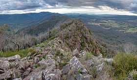
The ridge of the Cathedral Range looking south. | |
 Cathedral Range State Park | |
| Nearest town or city | Buxton |
| Coordinates | 37°22′49″S 145°44′09″E / 37.38028°S 145.73583°ECoordinates: 37°22′49″S 145°44′09″E / 37.38028°S 145.73583°E |
| Area | 3,577 hectares (8,840 acres) |
| Managing authorities | Parks Victoria |
| Website | Cathedral Range State Park |
| See also | Protected areas of Victoria |
The Cathedral Range State Park[1] is a state park in Victoria, Australia which encompasses the spectacular Cathedral Range and adjacent Little River valley.[2][3] It is located to the east of the Maroondah Highway, between Buxton and Taggerty, approximately 150 kilometres (93 mi) north-east of Melbourne.
Location and features
The Cathedral Range State Park is a popular bushwalking destination for Victorians, as it provides a wide variety of terrain and is easily accessed from Melbourne. Managed trails cover the extent of the range, from Little Cathedral Peak at the north end of the range, through Cathedral Peak, North and South Jawbone, to Sugarloaf Peak at the south end. The trails carry signs warning of "steep and difficult terrain", as several of the higher trails require scrambling across rock formations. From Neds Gully carpark, the walk to Sugarloaf Peak via the Farmyard is listed as 4 hours one way.
The park has three camping areas: Cooks Mill in the centre of the park, which is accessible by vehicle, Neds Gully in the north which offers walk in camping from a nearby car park via a small footbridge over the Little River, and The Farmyard, which is on the range and only accessible by foot. An access road traverses the park from north to south and connects the two main camping areas, with the main entrance from the north.
In addition to bushwalking and camping, rock climbing and abseiling at Sugarloaf Peak and The Jawbones are popular activities.
92% of the park was burnt by the Black Saturday bushfires in February 2009.[3]

References
- ↑ "Collaborative Australian Protected Area Database CAPAD08". Department of Sustainability, Environment, Water, Populations and Communities, Commonwealth of Australia. 2008. Retrieved 29 January 2012.
- ↑ "Cathedral Range State Park". Parks Victoria. Retrieved 27 December 2012.
- ↑ 3.0 3.1 "Cathedral Range Park visitor guide" (PDF). Park Notes. Parks Victoria. May 2010. Retrieved 25 January 2012.
| ||||||||||||