Castrovirreyna Province
| Castrovirreyna | |
|---|---|
| Province | |
|
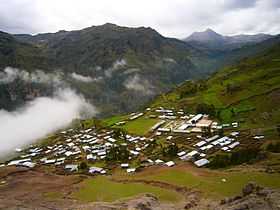
Awqa Urqu (in the background, on the right) as seen from Cochamarca (Quchamarka) in the southwest | |
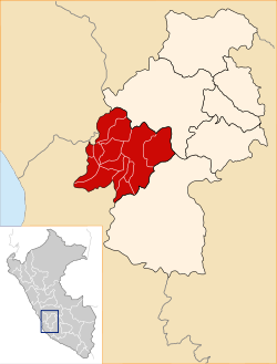 Location of Castrovirreyna in the Huancavelica Region | |
| Country | Peru |
| Region | Huancavelica |
| Capital | Castrovirreyna |
| Area | |
| • Total | 3,984.62 km2 (1,538.47 sq mi) |
| Population (2005 census) | |
| • Total | 20,018 |
| • Density | 5.0/km2 (13/sq mi) |
| UBIGEO | 0904 |
The Castrovirreyna Province is one of seven provinces located in the Huancavelica Region of Peru. The capital of this province is the city of Castrovirreyna.
Boundaries
- North: Huancavelica Province
- East: Huaytará Province
- South: Ica Region
- West: Lima Region
Geography
The Chunta mountain range traverses the province. Some of the highest peaks of the province are listed below:[1]
|
|
|
Political division
The province is divided into thirteen districts, which are:
- Arma (Arma)
- Aurahua (Aurahua)
- Capillas (Capillas)
- Castrovirreyna (Castrovirreyna)
- Chupamarca (Chupamarca)
- Cocas (Cocas)
- Huachos (Huachos)
- Huamatambo (Huamatambo)
- Mollepampa (Mollepampa)
- San Juan (San Juan)
- Santa Ana (Santa Ana)
- Tantara (Tantara)
- Ticrapo (Ticrapo)
Ethnic groups
The province is inhabited by indigenous citizens of Quechua descent. Spanish is the language which the majority of the population (77.20%) learnt to speak in childhood, 22.30% of the residents started speaking using the Quechua language (2007 Peru Census).[2]
See also
References
- ↑ escale.minedu.gob.pe/ UGEL map Castrovirreyna Province (Huancavelica Region)
- ↑ inei.gob.pe INEI, Peru, Censos Nacionales 2007
Coordinates: 12°47′09″S 74°58′22″W / 12.785833°S 74.972778°W