Castelleone
| Castelleone | |
|---|---|
| Comune | |
| Comune di Castelleone | |
 Castelleone Location of Castelleone in Italy | |
| Coordinates: 45°18′N 9°46′E / 45.300°N 9.767°ECoordinates: 45°18′N 9°46′E / 45.300°N 9.767°E | |
| Country | Italy |
| Region | Lombardy |
| Province | Province of Cremona (CR) |
| Frazioni | Le Valli, Corte Madama, Pradazzo, Guzzafame, Pellegra |
| Government | |
| • Mayor | Camillo Luigi Comandulli |
| Area | |
| • Total | 45.0 km2 (17.4 sq mi) |
| Elevation | 66 m (217 ft) |
| Population (Gen. 2006) | |
| • Total | 9,194 |
| • Density | 200/km2 (530/sq mi) |
| Demonym | Castelleonesi |
| Time zone | CET (UTC+1) |
| • Summer (DST) | CEST (UTC+2) |
| Postal code | 26012 |
| Dialing code | 0374 |
| Patron saint | Saints Philippe and James |
| Saint day | 11 May |
| Website | www.comune.castelleone.cr.it |
Castelleone is a comune (municipality) in the Province of Cremona in the Italian region of Lombardy, located about 50 kilometres (31 mi) southeast of Milan and about 30 kilometres (19 mi) northwest of Cremona. As of 31 December 2004, it had a population of 9,088 and an area of 45.0 square kilometres (17.4 sq mi).[1]
Castelleone borders the following municipalities: Cappella Cantone, Fiesco, Gombito, Izano, Madignano, Ripalta Arpina, San Bassano, Soresina, Trigolo.
Transportation
Castelleone has a railway station on the Treviglio–Cremona line.
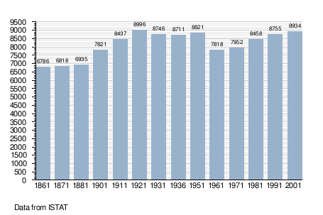
Demographic evolution

References
| Wikimedia Commons has media related to Castelleone. |