Casselman Bridge
| Casselman River Bridge State Park | |
| Maryland State Park | |
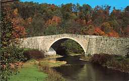 The bridge's south aspect | |
| Country | United States |
|---|---|
| State | Maryland |
| County | Garrett |
| Elevation | 2,113 ft (644 m) [1] |
| Coordinates | 39°41′48″N 79°08′37″W / 39.69667°N 79.14361°WCoordinates: 39°41′48″N 79°08′37″W / 39.69667°N 79.14361°W [1] |
| Area | 4 acres (2 ha) [2] |
| Established | Unspecified |
| Management | Maryland Department of Natural Resources |
| style=""color: #cde5b2"" | IUCN category | V - Protected Landscape/Seascape |
| Nearest city | Grantsville, Maryland |
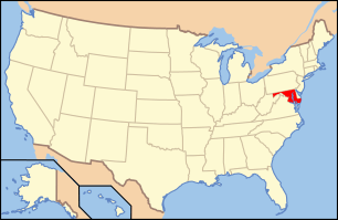
 Location in Maryland
| |
| Website: Casselman River Bridge State Park | |
|
Casselman's Bridge, National Road | |
| Location | East of Grantsville on U.S. Route 40 Alternate, Grantsville, Maryland |
| Built | 1813 |
| Architect | Unknown |
| Architectural style | Other |
| Governing body | Local |
| NRHP Reference # | 66000391 |
| Significant dates | |
| Added to NRHP | October 15, 1966[3] |
| Designated NHL | 29 January 1964[4] |
| Wikimedia Commons has media related to Casselman Bridge, National Road. |
Casselman Bridge, also known as Casselmans Bridge or Castleman's Bridge, was completed in 1811 and opened for traffic in 1813 to carry the National Road across the Casselman River near Grantsville in Garrett County, Maryland. The bridge and surrounding four acres are preserved as Casselman River Bridge State Park.
The 354-foot-long (108 m) stone arch bridge spans 48 feet (15 m) with a 30-foot-high (9.1 m) arch. It is located 0.5 miles (0.80 km) east of Grantsville, Maryland beside what is now US Route 40 Alternate and was declared a National Historic Landmark in 1964.[4] The bridge was built to aid in the westward movement through the wilderness west of Cumberland. While highway traffic no longer crosses the bridge, it remains in good condition.[5][6]
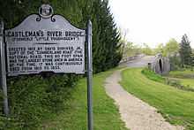
Historic markers posted at each end of the bridge read:
Erected 1813 by David Shriver, Jr., Sup't of the "Cumberland Road" (The National Road). This 80 foot span was the largest stone arch in America at the time. It was continuously used from 1813 to 1933.[7]
In the 1940s and early 1950s efforts were made to preserve the bridge. Sections of the bridge had started to crumble and fall apart. The bridge was patched and preserved as well as possible at the time. In 1979 the bridge was inspected structurally and rehabilitation plans were designed by Wallace, Montgomery & Associates, LLP, to help save the structure and return it to its original state.
The bridge is open to pedestrians, and there are fishing opportunities in Casselman River.[8] Historic Stanton's Mill lies adjacent to the park.
See also
- List of bridges documented by the Historic American Engineering Record in Maryland
- List of bridges on the National Register of Historic Places in Maryland
References
- ↑ 1.0 1.1 "Casselman Bridge". Geographic Names Information System. United States Geological Survey.
- ↑ "FY2013 DNR Owned Lands Acreage Report". Maryland DNR. Retrieved January 10, 2014.
- ↑ "National Register Information System". National Register of Historic Places. National Park Service. 2008-04-15.
- ↑ 4.0 4.1 "Casselmans Bridge, National Road". National Historic Landmark summary listing. National Park Service. Retrieved 2008-06-09.
- ↑ Joseph Scott Mendinghall (May 3, 1976). "National Register of Historic Places Inventory -- Nomination Form: Casselman Bridge, National Road". Maryland State Archives. Retrieved January 10, 2014.
- ↑ "Casselman Bridge, National Road". National Register Listings in Maryland. Maryland Historic Trust. Retrieved January 10, 2014.
- ↑ "Castleman’s River Bridge (Formerly "Little Youghiogeny")". The Historical Marker Database. Retrieved January 10, 2014.
- ↑ "Casselman River Bridge State Park". Maryland DNR. Retrieved January 10, 2014.
External links
- Casselman River Bridge State Park Maryland Department of Natural Resources
- Historic American Engineering Record (HAER) No. MD-128, "Little Crossings Bridge, National Road (U.S. Route 40) spanning Casselman River, Grantsville, Garrett County, MD", 2 measured drawings
- Historic American Buildings Survey (HABS) No. MD-139, "Casselman River Bridge, National Road (U.S. Route 40) at Little Crossings, Grantsville, Garrett County, MD", 3 photos
- Historic Casselman River Bridge The Traveling 219 Project (audio story)
| |||||||||||||||||||||||||

| ||||||