Casius quadrangle
|
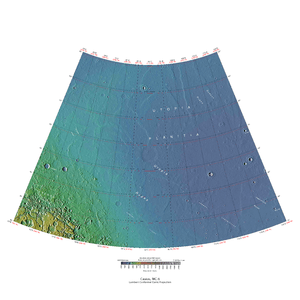
Map of Casius quadrangle from Mars Orbiter Laser Altimeter (MOLA) data. The highest elevations are red and the lowest are blue. | |
| Coordinates | 47°30′N 270°00′W / 47.5°N 270°WCoordinates: 47°30′N 270°00′W / 47.5°N 270°W |
|---|---|
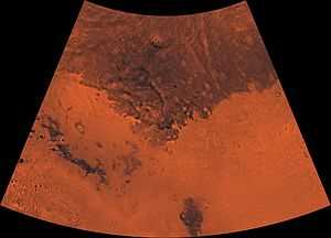
The Casius quadrangle is one of a series of 30 quadrangle maps of Mars used by the United States Geological Survey (USGS) Astrogeology Research Program. The quadrangle is located in the north central portion of Mars’ eastern hemisphere and covers 60° to 120° east longitude (240° to 300° west longitude) and 30° to 65° north latitude. The quadrangle uses a Lambert conformal conic projection at a nominal scale of 1:5,000,000 (1:5M). The Casius quadrangle is also referred to as MC-6 (Mars Chart-6).[1] Casius quadrangle contains part of Utopia Planitia and a small part of Terra Sabaea. The southern and northern borders of the Casius quadrangle are approximately 3,065 km and 1,500 km wide, respectively. The north to south distance is about 2,050 km (slightly less than the length of Greenland).[2] The quadrangle covers an approximate area of 4.9 million square km, or a little over 3% of Mars’ surface area.[3]
Origin of Name
Casius is the name of a telescopic albedo feature located at 40° N and 100° E on Mars. The feature was named for the Latin epithet for Zeus from his sanctuaries in Egypt and Syria. The name was approved by the International Astronomical Union (IAU) in 1958.[4]
Physiography and Geology
The high latitude Casius quadrangle bears several features that are believed to indicate the presence of ground ice. Patterned ground is one such feature. Usually, polygonal shapes are found poleward of 55 degrees latitude.[5] Other features associated with ground ice are Scalloped Topography,[6] Ring Mold Craters, and Concentric Crater Fill.
-

Map of Casius quadrangle with major features labeled.
-
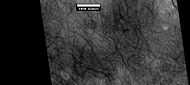
Patterned ground in the form of polygonal features is associated with ground ice. It is rare to be found this far south (45 degrees north latitude). Picture taken by Mars Global Surveyor.
-

Scalloped ground, as seen by HiRISE under HiWish program.
-

Close up of scalloped ground, as seen by HiRISE under HiWish program. Surface is divided into polygons; these forms are common where ground freezes and thaws. Note: this is an enlargement of a previous image.
-

Scalloped ground, as seen by HiRISE under HiWish program.
-

Close-up of scalloped ground, as seen by HiRISE under HiWish program. Surface is divided into polygons; these forms are common where ground freezes and thaws. Note: this is an enlargement of a previous image.
-

Periglacial Forms in Utopia, as seen by HiRISE. Click on image to see patterned ground and Scalloped Topography.
Nilosyrtis
Nilosyrtis runs from about 280 to 304 degrees west longitude, so like several other features, it sits in more than one quadrangle. Part of Nilosyrtis is in the Ismenius Lacus quadrangle, the rest is in Casius quadrangle.
-
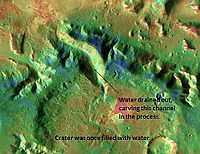
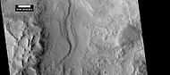
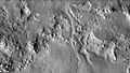
Channel in Nilosyrtis that was formed when a lake in a 45-mile-wide crater drained, as seen by THEMIS.
-

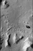
Landing Site in Nilosyrtis, as seen by THEMIS. Site is flat and contains water-altered clay minerals.
-

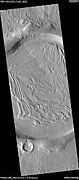
Nilosyrtis, as seen by HiRISE. Click on image to see layers.
Ring Mold Craters
Ring Mold Craters look like the ring molds used in baking. They are believed to be caused by an impact into ice. The ice is covered by a layer of debris. They are found in parts of Mars that have buried ice. Laboratory experiments confirm that impacts into ice result in a "ring mold shape."[7][8][9] They may be an easy way for future colonists of Mars to find water ice.
-

CTX context image for next image taken with HiRISE. Box indicates image footprint of following image.
-

Possible ring mold crater, as seen by HiRISE under the HiWish program. Crater shape is due to impact into ice.
-

Ring-mold craters form when an impact goes through to an ice layer. The rebound forms the ring-mold shape, and then dust and debris settle on the top to insulate the ice.
Concentric Crater Fill
Concentric crater fill is when the floor of a crater is mostly covered with a large number of parallel ridges.[10] They are thought to result from a glacial type of movement.[11][12] Sometimes boulders are found on concentric crater fill; it is believed they fell off crater wall, and then were transported away from the wall with the movement of the glacier.[13][14]Erratics on Earth were carried by similar means. Based on accurate topography measures of height at different points in these craters and calculations of how deep the craters should be based on their diameters, it is thought that the craters are 80% filled with mostly ice. That is, they hold hundreds of meters of material that probably consists of ice with a few tens of meters of surface debris.[15] The ice accumulated in the crater from snowfall in previous climates.[16]
High resolution pictures taken with HiRISE reveal that some of the surfaces of concentric crater fill are covered with strange patterns called closed-cell and open-cell brain terrain. The terrain resembles a human brain. It is believed to be caused by cracks in the surface accumulating dust and other debris, together with ice sublimating from some of the surfaces.[17]
-
Wide-view of concentric crater fill, as seen by HiRISE.
-

Concentric Crater Fill Close-up of near the top of previous image, as seen by HiRISE. The surface debris covers water ice.
-
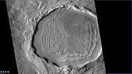
Crater with concentric crater fill, as seen by CTX (on Mars Reconnaissance Orbiter). Location is Casius quadrangle.
-

Well-developed hollows, as seen by HiRISE under the HiWish program. Location is the Casius quadrangle. Note: this is an enlargement of the previous image that was taken by CTX.
-

Close-up that shows cracks containing pits on the floor of a crater containing concentric crater fill, as seen by HiRISE under HiWish program.
-
Close-up that shows cracks containing pits on the floor of a crater, as seen by HiRISE under HiWish program. Cracks may start as a line of pits that enlarge, then join.
Climate change caused ice-rich features
Many features on Mars, including many in Casius quadrangle, are believed to contain large amounts of ice. The most popular model for the origin of the ice is climate change from large changes in the tilt of the planet's rotational axis. At times the tilt has even been greater than 80 degrees[18][19] Large changes in the tilt explains many ice-rich features on Mars.
Studies have shown that when the tilt of Mars reaches 45 degrees from its current 25 degrees, ice is no longer stable at the poles.[20] Furthermore, at this high tilt, stores of solid carbon dioxide (dry ice) sublimate, thereby increasing the atmospheric pressure. This increased pressure allows more dust to be held in the atmosphere. Moisture in the atmosphere will fall as snow or as ice frozen onto dust grains. Calculations suggest this material will concentrate in the mid-latitudes.[21][22] General circulation models of the Martian atmosphere predict accumulations of ice-rich dust in the same areas where ice-rich features are found.[23] When the tilt begins to return to lower values, the ice sublimates (turns directly to a gas) and leaves behind a lag of dust.[24][25][26] The lag deposit caps the underlying material so with each cycle of high tilt levels, some ice-rich mantle remains behind.[27] Note, that the smooth surface mantle layer probably represents only relative recent material.
Mars Science Laboratory
Nilosyrtis is one of the sites proposed as a landing site for the Mars Science Laboratory. However, it did not make the final cut. It was in the top 7, but not in the top 4. The aim of the Mars Science Laboratory is to search for signs of ancient life. It is hoped that a later mission could then return samples from sites identified as probably containing remains of life. To safely bring the craft down, a 12-mile-wide, smooth, flat circle is needed. Geologists hope to examine places where water once ponded.[28] They would like to examine sediment layers.
Layers
Many places on Mars show rocks arranged in layers. A detailed discussion of layering with many Martian examples can be found in Sedimentary Geology of Mars.[29] Rock can form layers in a variety of ways. Volcanoes, wind, or water can produce layers.[30] Layers may be formed by groundwater rising up depositing minerals and cementing sediments. The hardned layers are consequently more protected from erosion. This process may occur instead of layers forming under lakes.
-
Layers, as seen by HiRISE under HiWish program.
-

Layers in Monument Valley. These are accepted as being formed, at least in part, by water deposition. Since Mars contains similar layers, water remains as a major cause of layering on Mars.
Pedestal craters
-
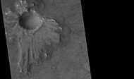
Pedestal crater, as seen by HiRISE under HiWish program The ejecta is not symmetrical around crater because the asteroid came at a low angle out of the North East. The ejecta protected the underlying material from erosion; hence the crater looks elevated.
-
Close-up of East side (right side) of previous image of pedestal crater showing polygons on lobe. Since the margin of the crater has lobes and polygons, it is believed there is ice under the protective top. Picture taken with HiRISE under HiWish program. Note: this is an enlargement of the previous image.
Other Views from Casius
-

Crater in the Adamas Labyrinthus Region, as seen by HiRISE. The original image shows many interesting details.
-

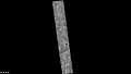
Bacolor Crater Ejecta, as seen by HiRISE. Scale bar is 1000 meters long.
-
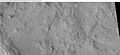
Astapus Colles Mounds and Knobs, as seen by HiRISE. Scale bar is 500 meters long.
-

Surface of Nilosyrtis Mensae showing ridges and cracks, as seen by HiRISE, under the HiWish program.
-

Another view of surface of Nilosyrtis Mensae, as seen by HiRISE, under the HiWish program.
-
CTX image showing area in next image.
-

Layers in craters, as seen by HiRISE under the HiWish program. Area was probably covered over by these layers; the layers have now eroded away except for the protected interior of craters.
-

Dikes as seen by HiRISE under the HiWish program.
-

Pits that seem to be forming cracks, as seen by HiRISE under HiWish program.
-

Holes and hollows on crater floor, as seen by HiRISE under HiWIsh program.
-
Field of low center polygons near crater, as seen by HiRISE under HiWish program These features are common where the ground freezes and thaws.
-

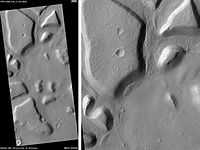
Renaudot Crater, as seen by CTX camera (on Mars Reconnaissance Orbiter). Dark dots are dunes.
-

Dunes and old glaciers in Renaudot Crater, as seen by CTX camera (on Mars Reconnaissance Orbiter). Arrows point to old glaciers along the crater wall. Note: this is an enlargement of the previous image.
-
Baldet Crater (Martian Crater), as seen by CTX camera (on Mars Reconnaissance Orbiter).
-
Channels on North wall of Baldet Crater, as seen by CTX camera (on Mars Reconnaissance Orbiter). Note: this is an enlargement of the previous image of Baldet Crater.
-

Dunes on floor of Baldet Crater, as seen by CTX camera (on Mars Reconnaissance Orbiter). Note: this is an enlargement of a previous image of Baldet Crater.
-
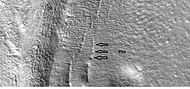
Dust devil tracks, as seen by HiRISE under HiWish program. Location is Casius quadrangle.
See also
- Climate of Mars
- Concentric Crater Fill
- Geology of Mars
- Impact crater
- List of quadrangles on Mars
- Patterned ground
- Scalloped Topography
- Water on Mars
- Ring mold crater
- Glaciers on Mars
| Wikimedia Commons has media related to Casius quadrangle. |
References
- ↑ Davies, M.E.; Batson, R.M.; Wu, S.S.C. “Geodesy and Cartography” in Kieffer, H.H.; Jakosky, B.M.; Snyder, C.W.; Matthews, M.S., Eds. Mars. University of Arizona Press: Tucson, 1992.
- ↑ Distances calculated using NASA World Wind measuring tool. http://worldwind.arc.nasa.gov/.
- ↑ Approximated by integrating latitudinal strips with area of R^2 (L1-L2)(cos(A)dA) from 30° to 65° latitude; where R = 3889 km, A is latitude, and angles expressed in radians. See: http://stackoverflow.com/questions/1340223/calculating-area-enclosed-by-arbitrary-polygon-on-earths-surface.
- ↑ USGS Gazetteer of Planetary Nomenclature. Mars. http://planetarynames.wr.usgs.gov/.
- ↑ Mangold, N. 2005. High latitude paterned grounds on Mars: Classification, distribution and climatic control. Icarus. 174-336-359.
- ↑ http://hiroc.lpl.arizona.edu/images/PSP/diafotizo.php?ID=PSP_002296_1215
- ↑ Kress, A., J. Head. 2008. Ring-mold craters in lineated valley fill and lobate debris aprons on Mars: Evidence for subsurface glacial ice. Geophys.Res. Lett: 35. L23206-8
- ↑ Baker, D. et all. 2010. Flow patterns of lobate debris aprons and lineated valley fill north of Ismeniae Fossae, Mars: Evidence for extensive mid-latitude glaciation in the Late Amazonian. Icarus: 207. 186-209
- ↑ Kress., A. and J. Head. 2009. Ring-mold craters on lineated valley fill, lobate debris aprons, and concentric crater fill on Mars: Implications for near-surface structure, composition, and age. Lunar Planet. Sci: 40. abstract 1379
- ↑ http://hiroc.lpl.arizona.edu/images/PSP/diafotizo.php?ID=PSP_111926_2185
- ↑ Head, J. et al. 2006. Extensive valley glacier deposits in the northern mid-latitudes of Mars: Evidence for late Amazonian obliquity-driven climate change. Earth Planet. Sci Lett: 241. 663-671.
- ↑ Levy, J. et al. 2007. Lineated valley fill and lobate debris apron stratigraphy in Nilosyrtis Mensae, Mars: Evidence for phases of glacial modification of the dichotomy boundary. J. Geophys. Res: 112.
- ↑ Marchant, D. et al. 2002. Formation of patterned ground and sublimation till over Miocene glacier ice in Beacon valley, southern Victorialand, Antarctica. Geol. Soc. Am. Bull:114. 718-730.
- ↑ Head, J. and D. Marchant. 2006. Modification of the walls of a Noachian crater in northern Arabia Terra (24E, 39N) during mid-latitude Amazonian glacial epochs on Mars: Nature and evolution of lobate debris aprons and their relationships to lineated valley fill and glacial systems. Lunar Planet. Sci: 37. Abstract # 1126.
- ↑ Garvin, J. et al. 2002. Global geometric properties of martian impact craters. Lunar Planet. Sci: 33. Abstract # 1255.
- ↑ Kreslavsky, M. and J. Head. 2006. Modification of impact craters in the northern planes of Mars: Implications for the Amazonian climate history. Meteorit. Planet. Sci.: 41. 1633-1646
- ↑ Ley, J. et al. 2009. Concentric crater fill in Utopia Planitia: History and interaction between glacial "brain terrain" and periglacial processes. Icarus: 202. 462-476.
- ↑ Touma J. and J. Wisdom. 1993. The Chaotic Obliquity of Mars. Science 259, 1294-1297.
- ↑ Laskar, J., A. Correia, M. Gastineau, F. Joutel, B. Levrard, and P. Robutel. 2004. Long term evolution and chaotic diffusion of the insolation quantities of Mars. Icarus 170, 343-364.
- ↑ Levy, J., J. Head, D. Marchant, D. Kowalewski. 2008. Identification of sublimation-type thermal contraction crack polygons at the proposed NASA Phoenix landing site: Implications for substrate properties and climate-driven morphological evolution. Geophys. Res. Lett. 35. doi:10.1029/2007GL032813.
- ↑ Levy, J., J. Head, D. Marchant. 2009a. Thermal contraction crack polygons on Mars: Classification, distribution, and climate implications from HiRISE observations. J. Geophys. Res. 114. doi:10.1029/2008JE003273.
- ↑ Hauber, E., D. Reiss, M. Ulrich, F. Preusker, F. Trauthan, M. Zanetti, H. Hiesinger, R. Jaumann, L. Johansson, A. Johnsson, S. Van Gaselt, M. Olvmo. 2011. Landscape evolution in Martian mid-latitude regions: insights from analogous periglacial landforms in Svalbard. In: Balme, M., A. Bargery, C. Gallagher, S. Guta (eds). Martian Geomorphology. Geological Society, London. Special Publications: 356. 111-131
- ↑ Laskar, J., A. Correia, M. Gastineau, F. Joutel, B. Levrard, and P. Robutel. 2004. Long term evolution and chaotic diffusion of the insolation quantities of Mars. Icarus 170, 343-364.
- ↑ Mellon, M., B. Jakosky. 1995. The distribution and behavior of Martian ground ice during past and present epochs. J. Geophys. Res. 100, 11781–11799.
- ↑ Mellon, M., B. Jakosky. 1995. The distribution and behavior of Martian ground ice during past and present epochs. J. Geophys. Res. 100, 11781–11799.
- ↑ Schorghofer, N., 2007. Dynamics of ice ages on Mars. Nature 449, 192–194.
- ↑ Madeleine, J., F. Forget, J. Head, B. Levrard, F. Montmessin. 2007. Exploring the northern mid-latitude glaciation with a general circulation model. In: Seventh International Conference on Mars. Abstract 3096.
- ↑ http://themis.asu.edu/features/ianichaos
- ↑ Grotzinger, J. and R. Milliken (eds.). 2012. Sedimentary Geology of Mars. SEPM.
- ↑ "HiRISE | High Resolution Imaging Science Experiment". Hirise.lpl.arizona.edu?psp_008437_1750. Retrieved 2012-08-04.
External links

| Quadrangles on Mars | |||||||||||||||||||||||
|---|---|---|---|---|---|---|---|---|---|---|---|---|---|---|---|---|---|---|---|---|---|---|---|
| MC-01 Mare Boreum (features) | |||||||||||||||||||||||
| MC-05 Ismenius Lacus (features) |
MC-06 Casius (features) |
MC-07 Cebrenia (features) |
MC-02 Diacria (features) |
MC-03 Arcadia (features) |
MC-04 Acidalium (features) | ||||||||||||||||||
| MC-12 Arabia (features) |
MC-13 Syrtis Major (features) |
MC-14 Amenthes (features) |
MC-15 Elysium (features) |
MC-08 Amazonis (features) |
MC-09 Tharsis (features) |
MC-10 Lunae Palus (features) |
MC-11 Oxia Palus (features) | ||||||||||||||||
| MC-20 Sinus Sabaeus (features) |
MC-21 Iapygia (features) |
MC-22 Mare Tyrrhenum (features) |
MC-23 Aeolis (features) |
MC-16 Memnonia (features) |
MC-17 Phoenicis Lacus (features) |
MC-18 Coprates (features) |
MC-19 Margaritifer Sinus (features) | ||||||||||||||||
| MC-27 Noachis (features) |
MC-28 Hellas (features) |
MC-29 Eridania (features) |
MC-24 Phaethontis (features) |
MC-25 Thaumasia (features) |
MC-26 Argyre (features) | ||||||||||||||||||
| MC-30 Mare Australe (features) | |||||||||||||||||||||||