Casitas Dam
| Casitas Dam | |
|---|---|
 | |
| Location |
Los Padres National Forest Ventura County, California |
| Coordinates | 34°22′42″N 119°19′51″W / 34.3783°N 119.3309°WCoordinates: 34°22′42″N 119°19′51″W / 34.3783°N 119.3309°W |
| Construction began | 1956 |
| Opening date | 1959 |
| Operator(s) | Bureau of Reclamation |
| Dam and spillways | |
| Impounds | Coyote Creek |
| Height | 334 ft (102 m) |
| Length | 2,000 ft (610 m) |
| Reservoir | |
| Creates | Lake Casitas |
| Total capacity | 254,000 acre·ft (313,000,000 m3) |
| Catchment area | 39 sq mi (100 km2) |
| Surface area | 2,700 acres (1,100 ha) |
| U.S. Geological Survey Geographic Names Information System: Casitas Dam | |
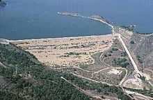
Casitas Dam is an earthfill dam across Coyote Creek that forms Lake Casitas in the Los Padres National Forest of Ventura County, California near Ojai, California. The dam is located two miles (3 km) above the junction of Coyote Creek and the Ventura River. Water from the Ventura River is diverted to Lake Casitas as well. The 334 ft (102 m) structure was built by the U.S. Bureau of Reclamation. It is a key part of the Ventura River Project. Construction was completed in 1959. Lake Casitas has a 254,000 acre·ft (313,000,000 m3) storage capacity and provides irrigation and municipal uses for the Casitas Municipal Water District.
See also
References
- Bureau of Reclamation (2009). "Casitas Dam". U.S. Department of the Interior. Retrieved 2009-10-11.
- Department of Water Resources (2009). "Station Meta Data: Casitas Dam (CSI)". California Data Exchange Center. State of California. Retrieved 2009-10-11.
- Bureau of Reclamation (2009). "Ventura River Project". U.S. Department of the Interior. Retrieved 2009-10-11.
External links
- U.S. Geological Survey Geographic Names Information System: Casitas Dam
- U.S. Geological Survey Geographic Names Information System: Lake Casitas
- Lake Casitas Recreation Area