Cascade Peaks
This article is about the peaks in the Pyrenees. For the North American mountain range, see Cascade Range.
| Cascade Peaks | |
|---|---|
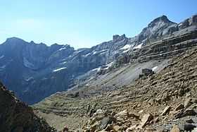 looking south: the oriental, central and western Cascade peaks (second, third and fourth from left respectively) | |
| Elevation | 3095, 3106, 3095[1] |
| Listing | List of Pyrenean three-thousanders |
| Location | |
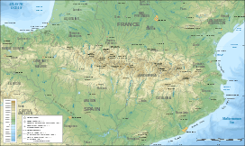 Cascade Peaks Location in the Pyrenees | |
| Location | France — Spain |
| Range | Pyrenees |
| Coordinates | 42°41′12″N 0°00′08″E / 42.68667°N 0.00222°ECoordinates: 42°41′12″N 0°00′08″E / 42.68667°N 0.00222°E |
| Geology | |
| Age of rock | Sélandien-Thanétien pour les roches[2] |
The Cascade Peaks are three summits in the Monte Perdido Range of the Pyrenees, culminating at 3,161 m (10,371 ft) on the oriental peak. The central peak or pic Brulle and the western peak are 3,106 m (10,190 ft)[3] and 3,095 m (10,154 ft) high, respectively. The peaks are located on the 3,000 m French-Spanish borderline crest.
Toponymy
The central summit was named in honor of Henri Brulle.
Geography
The peaks are part of range above Cirque de Gavarnie. The peaks are located in the Hautes-Pyrénées department, Midi-Pyrénées region of France, and in Huesca province, Aragon region of Spain.
Geology
The summit is composed of massive algae sediments, miliolitic sediments and sandstone sediments from the early Paleogene period.[4]
References
- ↑ Géoportail (site en ligne)
- ↑ Source : cartes géologiques à l'échelle 1:50000 du Bureau de recherches géologiques et minières (site en ligne).
- ↑ Géoportail
- ↑ Bureau des recherches géologiques et minières