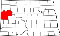
Cartwright, North Dakota
| Cartwright | |
|---|---|
| Unincorporated community | |
 Cartwright Location within the state of North Dakota | |
| Coordinates: 47°51′35″N 103°55′35″W / 47.85972°N 103.92639°WCoordinates: 47°51′35″N 103°55′35″W / 47.85972°N 103.92639°W | |
| Country | United States |
| State | North Dakota |
| County | McKenzie |
| Elevation | 1,906 ft (581 m) |
| Time zone | Central (CST) (UTC-6) |
| • Summer (DST) | CDT (UTC-5) |
| ZIP codes | 58838 |
| GNIS feature ID | 1034764 |
Cartwright is an unincorporated community in northwestern McKenzie County, North Dakota, United States. The community is named for Samuel George Cartwright, a rancher, trapper, and hunter, who was the first settler in the area. It lies along North Dakota Highway 200 west of the city of Watford City, the county seat of McKenzie County.[1] Its elevation is 1,906 feet (581 m).[2] Although it is unincorporated, it has a post office, with the ZIP code of 58838.[3]
Climate
According to the Köppen Climate Classification system, Cartwright has a semi-arid climate, abbreviated "BSk" on climate maps.[4]
References
- ↑ Rand McNally. The Road Atlas '08. Chicago: Rand McNally, 2008, p. 77.
- ↑ U.S. Geological Survey Geographic Names Information System: Cartwright, North Dakota, Geographic Names Information System, 1980-02-13. Accessed 2008-03-29.
- ↑ Zip Code Lookup
- ↑ Climate Summary for Cartwright, North Dakota
External links
| |||||||||||||||||||||||||||||
