Cartosio
| Cartosio | ||
|---|---|---|
| Comune | ||
| Comune di Cartosio | ||
| ||
 Cartosio Location of Cartosio in Italy | ||
| Coordinates: 44°36′N 8°25′E / 44.600°N 8.417°ECoordinates: 44°36′N 8°25′E / 44.600°N 8.417°E | ||
| Country | Italy | |
| Region | Piedmont | |
| Province | Province of Alessandria (AL) | |
| Area | ||
| • Total | 16.7 km2 (6.4 sq mi) | |
| Population (Dec. 2004) | ||
| • Total | 782 | |
| • Density | 47/km2 (120/sq mi) | |
| Time zone | CET (UTC+1) | |
| • Summer (DST) | CEST (UTC+2) | |
| Postal code | 15015 | |
| Dialing code | 0144 | |
Cartosio is a comune (municipality) in the Province of Alessandria in the Italian region Piedmont, located about 80 kilometres (50 mi) southeast of Turin and about 40 kilometres (25 mi) southwest of Alessandria. As of 31 December 2004, it had a population of 782 and an area of 16.7 square kilometres (6.4 sq mi).[1]
Cartosio borders the following municipalities: Castelletto d'Erro, Cavatore, Malvicino, Melazzo, Montechiaro d'Acqui, Pareto, and Ponzone.
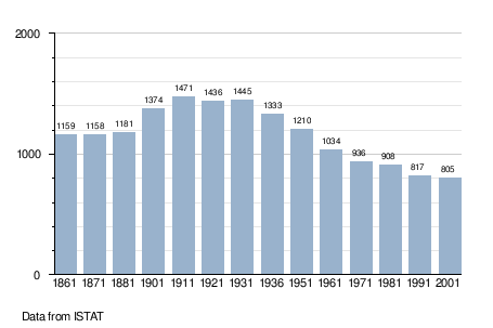
Demographic evolution