Carterton, New Zealand
| Carterton Taratahi | |
|---|---|
| Minor urban area | |
|
Central Carterton | |
| Motto: Daffodil capital | |
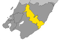 Location of Carterton District within Wellington Region | |
| Coordinates: 41°02′S 175°32′E / 41.033°S 175.533°ECoordinates: 41°02′S 175°32′E / 41.033°S 175.533°E | |
| Country |
|
| Region | Wellington |
| Territorial Authority | Carterton District |
| Town founded | 1857 |
| Electorate | Wairarapa |
| Government | |
| • Mayor | John Booth [1] |
| Area | |
| • Territorial | 1,180 km2 (460 sq mi) |
| • Urban | 5.12 km2 (1.98 sq mi) |
| Elevation | 77 m (253 ft) |
| Population (June 2014 estimate)[2] | |
| • Territorial | 8,680 |
| • Density | 7.4/km2 (19/sq mi) |
| • Urban | 4,980 |
| • Urban density | 970/km2 (2,500/sq mi) |
| Time zone | NZST (UTC+12) |
| • Summer (DST) | NZDT (UTC+13) |
| Postcode(s) | 5713, 5743, 5791, 5792 |
| Area code(s) | 06 |
| Website | www.cartertondc.govt.nz |
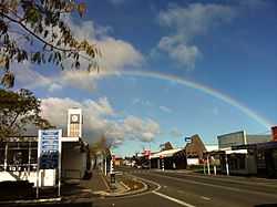
Carterton is a small town in the Wellington Region of New Zealand and the seat of the Carterton District. It lies in a farming area of the Wairarapa in New Zealand's North Island. It is located 14 kilometres (8.7 mi) southwest of Masterton and 80 kilometres (50 mi) northeast of Wellington. The town has a population of 4,980 (June 2014 estimate), out of a total district population of 8,680.[2]
Carterton was founded in 1857. Originally known as Three Mile Bush, and served as housing for workers building the road between Wellington and Masterton. It was later renamed after Charles Carter[3] who was in charge of the building of the Black Bridge over the Waiohine River south of the town.[4] The town describes itself as New Zealand's daffodil capital, holding a Daffodil Festival each year on the second Sunday in September.
History
Carterton claimed to be the first place in the world with a transsexual mayor, Georgina Beyer. Beyer went on to become the MP for Wairarapa.
On 7 January 2012, a hot air balloon crashed just north of the town, killing eleven people and making headlines around the world. The balloon came into contact with a high-voltage power line supplying the town, resulting in the balloon catching fire and the town losing power briefly.
Notable locations
Carterton's town clock is located on High Street next to the post office. The existing tower was put into operation in September 1962, replacing the original clock tower atop the post office that was damaged in the 1942 Wairarapa earthquake.

Historic Carterton Railway Station is located west of the town centre off Belvedere Road. The station building at the station is original, having been built when the railway opened in 1880, and has accepted passenger services ever since. It is currently leased from KiwiRail Network by the Wairarapa Railway Restoration Society.
The Carterton District library on Holloway Street is New Zealand's oldest purpose-built library that is still in use as a library today.
The Carterton Events Centre[5] is also on Holloway Street. Opened in October 2011, this state-of-the-art, multi-purpose community facility is available for community and commercial use. Centrally located in the Wairarapa region, the Centre provides modern, flexible, spaces for all manner of events, shows, exhibitions, meetings and community gatherings. Interconnection of spaces throughout the Centre allows for separation and opening up of spaces to cater for different needs. The Events Centre belongs to the Carterton community, through the Carterton District Council.
Education
Carterton has three primary schools:
- Carterton School, a state full primary (Year 1–8) school with a roll of 290 students as of March 2015.[6] The school opened in 1861.
- South End School, a state full primary (Year 1–8) school with a roll of 137 students as of March 2015.[6] The school opened in 1962.
- St Mary's School, a state-integrated Catholic full primary (Year 1–8) school with a roll of 110 students as of March 2015.[6] The school opened in 1917 and integrated into the state education system in the early 1980s.
Carterton also has Ponatahi Christian School, a state-integrated composite (Year 1–13) Christian school with a roll of 94 students as of March 2015.[6] It was founded as a private school in 1978 and was originally sited at Ponatahi, southwest of Carterton. The school moved to its current site over the 1996–97 summer holidays, and integrated into the state education system in April 1998.
There are no state secondary schools in Carterton. The nearest secondary schools are Kuranui College, 10 km away in Greytown, and Wairarapa College and Makoura College 14 km and 15 km away respectively in Masterton.
Transport
Road
The main street through Carterton is High Street - split on either side of Holloway Street into High Street North and High Street South. Other main streets include Park Road, Belvedere Road, Brooklyn Road, Pembroke Street and Holloway Street (which all run approximately east-west) and Lincoln Road (which runs approximately north-south). Other notable streets include Costley Street, Kenwyn Drive and Frederick Street.
Carterton is served by State Highway 2, the main highway between Wellington and Masterton. The highway runs the length of High Street.
Carterton is served by bus route 200, which connects Carterton with Masterton, Greytown, Featherston and Martinborough.
Rail
Carterton lies on the Wairarapa Line, and is served by the Wairarapa Connection operated by Tranz Metro, connecting Carterton to Wellington. The train serves both Carterton Railway Station and Matarawa Railway Station southwest of the township.
Notable people
- Sir Bob Charles, golfer, first left-handed golfer to win a golf major (The Open Championship, 1963)
- Madeleine Marie Slavick, American writer
See also
- Carterton Railway Station
- Matarawa Railway Station
- Wairarapa
- Category:Mayors of Carterton, New Zealand
References
| Wikimedia Commons has media related to Carterton, New Zealand. |
- ↑ Yong, Alisa (29 October 2014). "New mayor 'rapt' to carry legacy". Wairarapa Times Age (Masterton: APN New Zealand). Retrieved 16 November 2014.
- ↑ 2.0 2.1 "Subnational Population Estimates: At 30 June 2014 (provisional)". Statistics New Zealand. 22 October 2014. Retrieved 2 November 2014. Also "Infoshare; Group: Population Estimates - DPE; Table: Estimated Resident Population for Urban Areas, at 30 June (1996+) (Annual-Jun)". Statistics New Zealand. 22 October 2014. Retrieved 2 November 2014.
- ↑ Sutherland, G. H. "Carter, Charles Rooking". Dictionary of New Zealand Biography. Te Ara - the Encyclopedia of New Zealand. Retrieved 28 March 2014.
- ↑ "Carterton Travel Guide". Jasons Travel Media.
- ↑ http://www.cartertonec.co.nz
- ↑ 6.0 6.1 6.2 6.3 "Directory of Schools - as at 7 April 2015". New Zealand Ministry of Education. Retrieved 2015-04-08.
- Reed, A. W. (2002). The Reed Dictionary of New Zealand Place Names. Auckland: Reed Books. ISBN 0-7900-0761-4.
- Schrader, Ben. "Wairarapa places - Carterton". Te Ara - the Encyclopedia of New Zealand. Retrieved 28 March 2014.